|
 CAMPING
IN ICELAND 2017 - Iceland's capital
city Reykjavík including visit to the Alþing Parliament, Hveragerđi and
Hengill geothermal area, Nesjavellir, south coast at Stokkseyri, Eyrarbakki and Þorlákshöfn, Þingvellir, Geysir
spouting hot springs, Gullfoss waterfalls,
and Selfoss: CAMPING
IN ICELAND 2017 - Iceland's capital
city Reykjavík including visit to the Alþing Parliament, Hveragerđi and
Hengill geothermal area, Nesjavellir, south coast at Stokkseyri, Eyrarbakki and Þorlákshöfn, Þingvellir, Geysir
spouting hot springs, Gullfoss waterfalls,
and Selfoss:
Approaching the Reykjavík conurbation:
traffic on the Ring Road was intense as we
approached the outer suburb of Mosfellsbær where we encountered the first speed
cameras seen in the whole of Iceland. Thankful for the sat-nav's reassuring
guidance, we threaded a way through Reykjavík's eastern suburbs on the first
stretch of dual carriageway seen so far in the country. Our recollections of Reykjavík
from 1972 were of a small town of wooden houses. Inevitably things had changed in 45
years, and the capital city now seemed no different from any other major
conurbation: an anonymous sprawl of concrete with commercial parks lining the
highway, aggressively speeding traffic, and a bewildering series of roundabouts
and intersections.
|
Click on 3 highlighted areas of
map
for details of
Reykjavík,
Þingvellir,
Geysir and Gullfoss |
 |
We branched off from Route 1 Ring Road onto the
Route 41 dual-carriageway (Click on Map 1 right) still amid busy city
traffic, and passed around the city towards the southern suburbs. The main
Reykjavík campsite, although close to the city centre, was notoriously
overcrowded and expensive, and instead we had chosen the better value and
hopefully more peaceful hostel-campsite in
 the southern suburb of Hafnarfjörður.
Our sat-nav guided us off the main Route 41 highway, which led out to Keflavík,
turning into a narrow residential street and eventually to the gates of
Hafnarfjörður Hostel-Camping. the southern suburb of Hafnarfjörður.
Our sat-nav guided us off the main Route 41 highway, which led out to Keflavík,
turning into a narrow residential street and eventually to the gates of
Hafnarfjörður Hostel-Camping.
Hafnarfjörður Hostel-Camping: still dazed from the city traffic, we were greeted at reception with a friendly
and helpful welcome; the lad even recalled our earlier phone enquiry. He gave us
city maps and details of bus times into Reykjavík, and the 10 minute walking
route to the bus stop. The hostel-campsite was run by the Scout Association,
and reception was well set up with all the information that visitors might
require. The charge was an all-inclusive 1,000kr/person, a worthwhile seniors'
reduction from the full price of 1,700kr. Electricity was a further 1,000kr, but
the small camping area fitted with power supplies was already full; the
adjoining open parkland (no power) was at this stage still almost empty. We
found a space down at the far end and settled in beneath a lava embankment,
looking across the public parkland towards a modern church up on a hill to where
the path to the bus stop led. The forecast still showed Monday and Wednesday as
the least wet days for visiting Reykjavík, although tomorrow was the Labour Day public holiday Monday
with a reduced bus service. The parkland camping area gradually filled up during
the evening with hire-cars/tents, and yet again we were woken by late arrivals
thoughtlessly slamming car doors.
 set astride Tjörnin City Lake") Bus into Reykjavík: a bright, sunny start with the forecast
now showing no rain during the day. We were away early for our first day in the
capital city, and followed the path from the camping area up past the modern
church, through a school grounds and residential area to a main road, to wait at
the Hraunbrún bus stop (Photo 1 - Bus into Reykjavík)
(see above left).
Even with Sunday/holiday reduced service, the #1 buses into the city ran Bus into Reykjavík: a bright, sunny start with the forecast
now showing no rain during the day. We were away early for our first day in the
capital city, and followed the path from the camping area up past the modern
church, through a school grounds and residential area to a main road, to wait at
the Hraunbrún bus stop (Photo 1 - Bus into Reykjavík)
(see above left).
Even with Sunday/holiday reduced service, the #1 buses into the city ran every
30 minutes, and the 10-50am bus came along promptly. We had the 210kr coins
ready for our seniors' tickets, and followed the stops into the city centre on our Strætó
(Icelandic bus network) map-print to get off at Lækjargata bus
stop. At this time of day on a public holiday, the city was still remarkably
quiet. every
30 minutes, and the 10-50am bus came along promptly. We had the 210kr coins
ready for our seniors' tickets, and followed the stops into the city centre on our Strætó
(Icelandic bus network) map-print to get off at Lækjargata bus
stop. At this time of day on a public holiday, the city was still remarkably
quiet.
Tjörnin (City Lake),
Reykjavík Ráðhúsið (City Hall), and the Icelandic topographical model-map
Íslandslíkan: we walked around the northern side of Tjörnin (City
Lake) to find the
Reykjavík Ráðhúsið (City Hall), a classic steel and glass rectangular piece of
Nordic showpiece architecture set astride the city lake and opened in 1992 (see
above left) (Photo
2 - Reykjavík Ráðhúsið). The
main hall of the building overlooking the lake contained a magnificent
topographical display of Iceland, the Íslandslíkan: a 4 man team had taken 5
years to construct this detailed relief model-map of the country to a horizontal
scale of 1:50k and vertical scale doubled for emphasis. We spent a good half
hour studying this impressive model (see right)
(Photo
3 - Topographical relief model), following our route around the county and trying to
identify places and features. Five aspects were of immediate notice:
- the immense mountainous scale of the East and West
Fjords areas
- the huge areas still covered by ice-sheets
and glaciers, particularly Vatnajökull in the east
- the comparatively flat and barren volcanic central plateau
areas of the country
- the evident transverse line of the
tectonic boundary ridge running SW~NE across the width of the country,
dotted with isolated volcanic peaks and craters such as Askja
- the vast extent of sandurs (glacial
outwash plains) along the indented southern coastline

") The startling
impression which the model gave of Iceland's severe terrain was a cautious alert to those considering driving around Iceland; even
the south coast where we were to travel next looked fearsome (see above right). The startling
impression which the model gave of Iceland's severe terrain was a cautious alert to those considering driving around Iceland; even
the south coast where we were to travel next looked fearsome (see above right).
We walked along the lake-side path of Tjörnin
taking photos in the pleasant morning sunshine, as local families fed the ducks
(see left) (Photo 4 - Feeding the ducks on Reykjavík's Tjörnin),
and sat on a bench to eat our lunch sandwiches
looking out across the lake towards the Hallgrímskirkja church on the opposite
city hillside
(see right). At the far end of the lake, the attractive old house of
Raðherrabústaðurinn (Minister's House) (see below right), once wooden and now faced with more
weather-resistant corrugated material, provided further photographic opportunity
as did the view looking down the length of Tjörnin towards the Ráðhúsið (see
below left).
Reykjavík Old Town:
back along past the Ráðhúsið, we walked through to the small-sized dark basalt
building of the Alþingishúsið, Parliament House.") The imposing front
façade,
inscribed with the date of construction The imposing front
façade,
inscribed with the date of construction 1881, was in deep shade at this time of
day, but around on the sunny south side, we entered the peaceful flower
gardens of the Alþing to photograph the building's rear façade
(Photo 5 - Alþing gardens). As part of the
trip's planning, we had exchanged emails with a member of the Alþing Secretariat
in an attempt to arrange a visit, and had been advised to make contact when we
arrived at Reykjavík; we were still hoping to arrange the visit for our second
day in the city on Wednesday.
1881, was in deep shade at this time of
day, but around on the sunny south side, we entered the peaceful flower
gardens of the Alþing to photograph the building's rear façade
(Photo 5 - Alþing gardens). As part of the
trip's planning, we had exchanged emails with a member of the Alþing Secretariat
in an attempt to arrange a visit, and had been advised to make contact when we
arrived at Reykjavík; we were still hoping to arrange the visit for our second
day in the city on Wednesday.
Round to Austurvöllur at the front of the
Alþing, this rather unassuming grassy parkland square has played an important
part in Reykjavík's historic past and in recent years of political and economic
turmoil. The square is said to be the site of the farm founded by Iceland's
first settler, Ingólfur Arnasson. Exiled from Norway for murdering the son of a
local earl in a blood feud, he sailed with his household and possessions for
Iceland around 870 AD, planning to settle there. In sight of land, Ingólfur
observed the Viking tradition of throwing overboard his wooden high seat
pillars, symbols of his chieftain's authority, vowing to settle wherever the
gods brought them ashore. It took 3 years for his slaves to find them, while
Ingólfur wintered along Iceland's south coast. According to, regarded as Reykjavík's founding father") the Icelandic Book
of Settlements (Landnámabók), the pillars were located in a SW bay, and
in 874 AD Ingólfur settled there, naming the place Reykjavík (meaning Smokey Bay)
after the steaming hot springs, and becoming Iceland's first permanent settler. Austurvöllur is traditionally viewed as the site of Ingólfur's farmstead, and the Icelandic Book
of Settlements (Landnámabók), the pillars were located in a SW bay, and
in 874 AD Ingólfur settled there, naming the place Reykjavík (meaning Smokey Bay)
after the steaming hot springs, and becoming Iceland's first permanent settler. Austurvöllur is traditionally viewed as the site of Ingólfur's farmstead, and
 now in the centre of the square a statue of Jón Sigurðsson, the 19th century
political agitator for Icelandic independence, entitled Pride of Iceland, its
Sword and Shields, stands facing the Alþing. now in the centre of the square a statue of Jón Sigurðsson, the 19th century
political agitator for Icelandic independence, entitled Pride of Iceland, its
Sword and Shields, stands facing the Alþing.
Along Kirkjustræti, we reached Aðalstræti, Reykjavík's oldest street said to be
the route taken by Ingólfur from his farmstead down to the sea. It is now a
rather nondescript street of restaurants occupying the old buildings; the oldest
of these at number 10, a wooden structure, was once a weaving shed and
also the home of Skúli Magnússon (1711~94) (see left), the 18th century High Sheriff of Iceland who
began Reykjavík's rise to become in time the capital by importing foreign
machinery to establish craft industries, opening mills and tanneries. The
broad-shouldered statue of Skúli Magnússon, the man regarded as the city's founding
father, stood at the
end of Aðalstræti (see right). At the far end, we reached the corner of Hafnartræti (Harbour
Street), so called since this land once bordered the sea, giving access to the
harbour. During the time of the 1602~1855 Trade Monopoly, wealthy Danish
merchants established their warehouses here, making it the centre of the city's
commercial life. Today Hafnartræti is several blocks inland from the modern
harbour which has been extended outwards on reclaimed land, and along with
neighbouring Austurstræti and Tryggvagata, is now coining in the tourist income,
filled with grubby-looking bars and restaurants.
 Reykjavík's Old Harbour and Harpa Opera House: Geirsgata led
us along to Reykjavík's Old Harbour area, which had been extended out on
reclaimed land in 1913~15; before this, larger vessels had to be moored out in
the bay and goods ferried in and out on smaller boats. Today there were still
shipyards repairing vessels up on stocks (see left), with piers now filled with small
fishing boats along with whale- and puffin-watching boats aimed at the tourist trade.
Ironically at a pier opposite the whale-watching boats, 2 whaling ships named
Hvalur 8 and 9 were moored (see right), identified by the H (for Hval) on
their funnels (Photo
6 - Whaling ships), although it did not look as if they had been to sea for a while.
Just along the quay however, a monstrous Danish cruise-ship polluted both the
visual skyline of the port and the clean sea air with its diesel fumes. We
ambled around to the far of the quays where behind securely locked security
gates, a large Icelandic coast-guard vessel was moored (see below left) (Photo
7 - Reykjavík Old Harbour); we wondered if this had
played any part in the Cod Wars, harassing British trawlers and severing trawl
lines! The quay-side path led around to the controversial Harpa Concert
Hall and Opera House. This huge, angular glass building was half-constructed in
2008 at the time of Iceland's economic crash, and at such a time of financial
hardship, politicians had demanded the scheme should be scrapped. The building
however went ahead, Reykjavík's Old Harbour and Harpa Opera House: Geirsgata led
us along to Reykjavík's Old Harbour area, which had been extended out on
reclaimed land in 1913~15; before this, larger vessels had to be moored out in
the bay and goods ferried in and out on smaller boats. Today there were still
shipyards repairing vessels up on stocks (see left), with piers now filled with small
fishing boats along with whale- and puffin-watching boats aimed at the tourist trade.
Ironically at a pier opposite the whale-watching boats, 2 whaling ships named
Hvalur 8 and 9 were moored (see right), identified by the H (for Hval) on
their funnels (Photo
6 - Whaling ships), although it did not look as if they had been to sea for a while.
Just along the quay however, a monstrous Danish cruise-ship polluted both the
visual skyline of the port and the clean sea air with its diesel fumes. We
ambled around to the far of the quays where behind securely locked security
gates, a large Icelandic coast-guard vessel was moored (see below left) (Photo
7 - Reykjavík Old Harbour); we wondered if this had
played any part in the Cod Wars, harassing British trawlers and severing trawl
lines! The quay-side path led around to the controversial Harpa Concert
Hall and Opera House. This huge, angular glass building was half-constructed in
2008 at the time of Iceland's economic crash, and at such a time of financial
hardship, politicians had demanded the scheme should be scrapped. The building
however went ahead,
 producing much derision and contention, and now dominates
the harbour sky-line (Photo
8 - Harpa Concert Hall). Now home to the producing much derision and contention, and now dominates
the harbour sky-line (Photo
8 - Harpa Concert Hall). Now home to the Icelandic Symphony Orchestra and National
Opera, Harpa should (according to our guide books) have been free entry
for visitors to amble around the spacious interior. But of course, in today's greed-driven, tourist
orientated Reykjavík, nothing comes for nothing any more: with everyone on the
make, the answer from an attendant was yes we could walk around, but only if we
paid an arm and a leg to join a guided tour. We wouldn't and we didn't! And
contented ourselves with photographs of the hexagonal panes of glass and the
reflective interior (see right). Icelandic Symphony Orchestra and National
Opera, Harpa should (according to our guide books) have been free entry
for visitors to amble around the spacious interior. But of course, in today's greed-driven, tourist
orientated Reykjavík, nothing comes for nothing any more: with everyone on the
make, the answer from an attendant was yes we could walk around, but only if we
paid an arm and a leg to join a guided tour. We wouldn't and we didn't! And
contented ourselves with photographs of the hexagonal panes of glass and the
reflective interior (see right).
Hallgrímskirkja hill-top church: from here
we edged a way through and around an enormous construction site for a new
underpass, which sullied this area of the city, and climbed the grassy hillock
topped by the statue of Ingólfur Arnasson. Strolling on, across to Lækjartorg,
we waded through the tourist hordes now filling unimpressive Austurtræti (see
below left) and
back along the equally uninteresting Hafnartræti. With the old part of Reykjavík
being so bijou, we had covered our planned ground, and with it still being only
3-30pm, we set off up Bankatræti and Skólavörðustígur to visit the Hallgrímskirkja
church (see below right), whose white concrete 73m high tower dominates the city sky-line from
 its
commanding hill-top position
(Photo 9 - Hallgrímskirkja Church). The Hallgrímskirkja is the most renowned work of
the Icelandic State Architect Guðjón Samúelsson, who also designed its
commanding hill-top position
(Photo 9 - Hallgrímskirkja Church). The Hallgrímskirkja is the most renowned work of
the Icelandic State Architect Guðjón Samúelsson, who also designed Akureyri
Church and Ísafjörður Culture House. The design was finalised in 1937 but work
only got underway after WW2 in 1945. Constructed from reinforced concrete, the
church was only completed and consecrated in 1986, as part of the City's
bicentennial celebrations. The slow rate of progress was due to the work being
carried out by a small family firm of one man and his son! Hallgrímskirkja is
dedicated to the 17th century Icelandic writer of passion hymns, Hallgrímur
Pétursson. The forecourt fronting the church is guarded over by an almost
comical statue of Leifur
Eiríksson (see below left), donated by the USA in 1930 on the occasion of the Icelandic
Parliament's millennium celebrations. The bare white lines of the church's
interior emphasised its peaceful Gothic height. Closer examination of the finish
suggested that the rough faced concrete lining was sprayed onto the structural
support elements. The west end was dominated by the church's huge concert organ
15m in height. Tourist numbers had been tolerable during earlier part of the
day, but as we had climbed the hill, hordes of the most gormless tourist
specimens milled everywhere, and now Hallgrímskirkja's plain chancel's solemnity
was sullied by crowd's of mindless tourists abusing the peaceful setting for
their ludicrous selfies. Akureyri
Church and Ísafjörður Culture House. The design was finalised in 1937 but work
only got underway after WW2 in 1945. Constructed from reinforced concrete, the
church was only completed and consecrated in 1986, as part of the City's
bicentennial celebrations. The slow rate of progress was due to the work being
carried out by a small family firm of one man and his son! Hallgrímskirkja is
dedicated to the 17th century Icelandic writer of passion hymns, Hallgrímur
Pétursson. The forecourt fronting the church is guarded over by an almost
comical statue of Leifur
Eiríksson (see below left), donated by the USA in 1930 on the occasion of the Icelandic
Parliament's millennium celebrations. The bare white lines of the church's
interior emphasised its peaceful Gothic height. Closer examination of the finish
suggested that the rough faced concrete lining was sprayed onto the structural
support elements. The west end was dominated by the church's huge concert organ
15m in height. Tourist numbers had been tolerable during earlier part of the
day, but as we had climbed the hill, hordes of the most gormless tourist
specimens milled everywhere, and now Hallgrímskirkja's plain chancel's solemnity
was sullied by crowd's of mindless tourists abusing the peaceful setting for
their ludicrous selfies.
 Return to camp at
Hafnarfjörður: leaving the hordes behind, we ambled down Njarðargata
and Laufásvegur to Tjörnin, and headed back towards the Alþing, hoping that the
sun might have worked its way around to light the front façade. But no, and with
the time now gone 5-00pm we found a bus stop in Vonarstræti by the Return to camp at
Hafnarfjörður: leaving the hordes behind, we ambled down Njarðargata
and Laufásvegur to Tjörnin, and headed back towards the Alþing, hoping that the
sun might have worked its way around to light the front façade. But no, and with
the time now gone 5-00pm we found a bus stop in Vonarstræti by the Ráðhúsið for
our return #1 bus to the campsite at
Hafnarfjörður (see left). It had been a highly successful first day. Reykjavík is certainly
not a startling capital city: it had mushroomed in size from the scattering of
wooden buildings recalled from 1972, but the old centre was still sufficiently
compact that you could walk from one side to the other in 20 minutes. But like
the country as a whole, the capital city was in danger of being utterly
overwhelmed by the mindless hordes of tourists now flooding here the whole year
round. But just looking around at these folk, you really are left wondering why
them come, so evidently incurious and indifferent to all they are seeing, and so
readily relieved of their money! Reykjavík could never be described as an
attractive city, and there is only so far that the contrived image of the
Vikings can be exploited by their modern day equivalents now universally on the
make to milk the tourist boom for a quick buck before the bubble bursts. Ráðhúsið for
our return #1 bus to the campsite at
Hafnarfjörður (see left). It had been a highly successful first day. Reykjavík is certainly
not a startling capital city: it had mushroomed in size from the scattering of
wooden buildings recalled from 1972, but the old centre was still sufficiently
compact that you could walk from one side to the other in 20 minutes. But like
the country as a whole, the capital city was in danger of being utterly
overwhelmed by the mindless hordes of tourists now flooding here the whole year
round. But just looking around at these folk, you really are left wondering why
them come, so evidently incurious and indifferent to all they are seeing, and so
readily relieved of their money! Reykjavík could never be described as an
attractive city, and there is only so far that the contrived image of the
Vikings can be exploited by their modern day equivalents now universally on the
make to milk the tourist boom for a quick buck before the bubble bursts.
A cold, wet day in camp at
Hafnarfjörður:
with rain forecast for the following day (our 47th wedding anniversary as it
happened), we should spend the day in camp and make full use of the
campsite's free washing machine. Before beginning a day's work this morning, we
telephoned the Alþing in an attempt to arrange a visit. The official we had
exchanged pre-trip emails with was on holiday, but to our amazement, a colleague
agreed to show us the Alþing at 12 noon tomorrow. Our visit to the Icelandic
Parliament was on. Today's rain was forecast to begin at 12-00, so late morning
we worked out a walking route to a Netto supermarket said to be in the nearby
housing estate. Sure enough the path led from the campsite up into the
residential area of apartment blocks and ticky-tacky pre-fabs, but this path had
a uniquely Icelandic tone to it, passing through a so late morning
we worked out a walking route to a Netto supermarket said to be in the nearby
housing estate. Sure enough the path led from the campsite up into the
residential area of apartment blocks and ticky-tacky pre-fabs, but this path had
a uniquely Icelandic tone to it, passing through a
 lava field which conveniently
had spread among the houses and a children's playground! We completed our provisions
shopping and returned for lunch in camp, and an afternoon of work. The rain
began as forecast at lunchtime, drizzle at first then more determined rain, with
a bitterly chill northern wind blowing. With no power for heating, George's
inside temperature dropped lower and lower reaching 12ºC. As the rain
intensified and continued all afternoon, we piled on multi-layered Arctic gear
for warmth, and that night with heavy cloud cover, it was unaccustomedly dark. lava field which conveniently
had spread among the houses and a children's playground! We completed our provisions
shopping and returned for lunch in camp, and an afternoon of work. The rain
began as forecast at lunchtime, drizzle at first then more determined rain, with
a bitterly chill northern wind blowing. With no power for heating, George's
inside temperature dropped lower and lower reaching 12ºC. As the rain
intensified and continued all afternoon, we piled on multi-layered Arctic gear
for warmth, and that night with heavy cloud cover, it was unaccustomedly dark.
Our visit to the Alþing, the Icelandic
Parliament:
the rain had stopped overnight, but this morning the sky was still heavily
overcast and air chill. We again walked up for the 10-50am bus from Hraunbrun,
and followed the now familiar stops into the city centre. We had a half hour
before our appointment at the Alþing, time to admire the statue of Iceland's
early 20th century Home Rule Prime Minister Hannes Hafstein outside Government
House in Lækjargata (see above right), which now houses the current Prime Minister's offices. We walked
through to Austurvöllur for photos of Jón Sigurðsson's statue, before reporting
to the Alþing for our visit (see left) (Photo
10 - Alþing - Icelandic Parliament).
") The Alþing, claimed by Icelanders as one of the
world's oldest extant parliamentary institutions, first met in 930 AD as a
general assembly (thing) of the Icelandic Commonwealth, when the country's most
powerful clan chieftains (Goðar), along with all Icelandic free men,
gathered on the plains at Þingvellir once a year to discuss issues, decide on
legislation, dispense justice, and resolve disputes. The centre of the gathering
was the Lögberg (Law Rock) from which the Lawspeaker recited the Laws and presided over the Assembly. When the Icelanders submitted to the authority of
the Norwegian monarchy in 1262 under the terms of the Old Covenant, the
supremacy of the Alþing was diminished, as executive power was now vested with
the King and his officials. The role of the Alþing became more judicial as a
national court after the crowns of Norway and Denmark merged and the Danish
king's rule became absolute. The Alþing was disbanded in 1800, but a royal
decree re-established it as a consultative body for the crown in 1843; from then
it became increasingly a forum for the Icelanders' long struggle for
independence f The Alþing, claimed by Icelanders as one of the
world's oldest extant parliamentary institutions, first met in 930 AD as a
general assembly (thing) of the Icelandic Commonwealth, when the country's most
powerful clan chieftains (Goðar), along with all Icelandic free men,
gathered on the plains at Þingvellir once a year to discuss issues, decide on
legislation, dispense justice, and resolve disputes. The centre of the gathering
was the Lögberg (Law Rock) from which the Lawspeaker recited the Laws and presided over the Assembly. When the Icelanders submitted to the authority of
the Norwegian monarchy in 1262 under the terms of the Old Covenant, the
supremacy of the Alþing was diminished, as executive power was now vested with
the King and his officials. The role of the Alþing became more judicial as a
national court after the crowns of Norway and Denmark merged and the Danish
king's rule became absolute. The Alþing was disbanded in 1800, but a royal
decree re-established it as a consultative body for the crown in 1843; from then
it became increasingly a forum for the Icelanders' long struggle for
independence f") rom Danish rule, led by the independence reformer Jón Sigurðsson
until his death in 1879. The Constitution granted to Iceland by Danish King Christian
IX in 1874 granted the Alþing legislative powers in domestic matters. Iceland
achieved Home Rule in 1904 with Hannes Hafstein as the first Prime Minister, and
became a sovereign state in a monarchical union with Denmark in 1918. Iceland
finally became a fully independent republic on 17 June 1944 (Jón Sigurðsson's
birthday and now Icelandic Independent Day), with the Alþing assuming full
legislative powers along with the Icelandic President. rom Danish rule, led by the independence reformer Jón Sigurðsson
until his death in 1879. The Constitution granted to Iceland by Danish King Christian
IX in 1874 granted the Alþing legislative powers in domestic matters. Iceland
achieved Home Rule in 1904 with Hannes Hafstein as the first Prime Minister, and
became a sovereign state in a monarchical union with Denmark in 1918. Iceland
finally became a fully independent republic on 17 June 1944 (Jón Sigurðsson's
birthday and now Icelandic Independent Day), with the Alþing assuming full
legislative powers along with the Icelandic President.
The lady official we had spoken with on the
telephone yesterday greeted us at the Alþing reception, and we began our tour of
the Parliament, discussing constitutional issues as we went. The modern day Alþing
is composed of 63 Members,") elected by proportional representation from the
country's 6 constituencies for a period of 4 years. Turnout in general elections
is usually around 80%. In the October 2016 election 7 parties took seats, but
with no party having an overall majority a period of political wrangling
followed; this resulted in a new coalition government being formed in January
2017, led by the Independence Party (21 seats) with Reform Party (7 seats) and
Bright Future Party (4 seats), controlling in total 32 seats. The Opposition
parties were: Left-Green Movement (10 seats), Pirate Party (10 seats),
Progressive Party (8 seats) and Social Democratic Alliance (3 seats), totalling
31 seats. The Independence Party leader Bjarni Benediktsson was appointed Prime
Minister. Of the 63 then serving MPs, 30 were women and 33 men. At its first
meeting of the new Parliament, the Alþing elects its Speaker from among its
members, and the lady-Speaker at the time of our visit was
Unnur Brá Konráðsdóttir. [Since our visit to Iceland, and following collapse of
the coalition government in September 2017, a further parliamentary snap
election in October resulted in a new coalition government being formed in
October 2017 led by Prime Minister Katrín
Jakobsdóttir of the Left-Green Movement who is still in office.] elected by proportional representation from the
country's 6 constituencies for a period of 4 years. Turnout in general elections
is usually around 80%. In the October 2016 election 7 parties took seats, but
with no party having an overall majority a period of political wrangling
followed; this resulted in a new coalition government being formed in January
2017, led by the Independence Party (21 seats) with Reform Party (7 seats) and
Bright Future Party (4 seats), controlling in total 32 seats. The Opposition
parties were: Left-Green Movement (10 seats), Pirate Party (10 seats),
Progressive Party (8 seats) and Social Democratic Alliance (3 seats), totalling
31 seats. The Independence Party leader Bjarni Benediktsson was appointed Prime
Minister. Of the 63 then serving MPs, 30 were women and 33 men. At its first
meeting of the new Parliament, the Alþing elects its Speaker from among its
members, and the lady-Speaker at the time of our visit was
Unnur Brá Konráðsdóttir. [Since our visit to Iceland, and following collapse of
the coalition government in September 2017, a further parliamentary snap
election in October resulted in a new coalition government being formed in
October 2017 led by Prime Minister Katrín
Jakobsdóttir of the Left-Green Movement who is still in office.]
 From the public gallery of the Alþing, we could
look down into the traditionally laid out Parliamentary chamber (Photo
11 - Alþing plenary chamber) (see above right). Members are
seated, not in party groupings, but places are assigned randomly at the first
session of the year by drawing of lots. Ministers sit along the front of the
chamber,
and members address the Parliament from the podium. The From the public gallery of the Alþing, we could
look down into the traditionally laid out Parliamentary chamber (Photo
11 - Alþing plenary chamber) (see above right). Members are
seated, not in party groupings, but places are assigned randomly at the first
session of the year by drawing of lots. Ministers sit along the front of the
chamber,
and members address the Parliament from the podium. The only concession
to modernity is the electronic voting system from each seat with results
displayed on monitors The Alþing changed from bicameral to unicameral only in
1991. As we walked around, we discussed current issues such as attitude to
accession to EU membership; a national referendum is still to be called, but
public concerns are about protection of fishing rights around Iceland from
continental competition and agricultural imports. We had been very fortunate to
have been able to arrange the visit despite most of the staff being on holiday
during the summer recess, and we had secured our photos of the Alþing
Parliamentary chamber. only concession
to modernity is the electronic voting system from each seat with results
displayed on monitors The Alþing changed from bicameral to unicameral only in
1991. As we walked around, we discussed current issues such as attitude to
accession to EU membership; a national referendum is still to be called, but
public concerns are about protection of fishing rights around Iceland from
continental competition and agricultural imports. We had been very fortunate to
have been able to arrange the visit despite most of the staff being on holiday
during the summer recess, and we had secured our photos of the Alþing
Parliamentary chamber.
Reykjavík's Cathedral, the Domkirkjan:
we walked round to Reykjavík's Cathedral, the Neoclassical Domkirkjan (see above left)
which was now open for us to see the galleried plain Lutheran interior (see
right). The
church was built in 1796 after Danish King Christian VII abolished the 2 former
Catholic bishoprics of Hólar and Skálholt and established the Lutheran bishopric
of Reykjavík. The small  cathedral is the venue for the pre-Parliamentary new
session's service followed by procession along to the Alþing, although larger
state ceremonial services are held up at the larger Hallgrímskirkja. We tried
lunching again on the bench looking across Tjörnin, but today with the heavily
overcast sky and drizzly rain beginning, it was less memorable than in Monday's
sunshine. cathedral is the venue for the pre-Parliamentary new
session's service followed by procession along to the Alþing, although larger
state ceremonial services are held up at the larger Hallgrímskirkja. We tried
lunching again on the bench looking across Tjörnin, but today with the heavily
overcast sky and drizzly rain beginning, it was less memorable than in Monday's
sunshine.
 National Museum of Iceland, Þóðminjasafn Íslands:
Tjarnargata took us alongside Tjörnin and up to the Icelandic National
Museum of Iceland (Þóðminjasafn Íslands), where a seniors' reduction combined
ticket of 1000kr gave entry here and the Culture House. The Museum's displays of
archaeological finds, artefacts, memorabilia and documents give a comprehensive
history of Iceland's development from its earliest settlement through to the
declaration of the Republic in 1944 and the present day. National Museum of Iceland, Þóðminjasafn Íslands:
Tjarnargata took us alongside Tjörnin and up to the Icelandic National
Museum of Iceland (Þóðminjasafn Íslands), where a seniors' reduction combined
ticket of 1000kr gave entry here and the Culture House. The Museum's displays of
archaeological finds, artefacts, memorabilia and documents give a comprehensive
history of Iceland's development from its earliest settlement through to the
declaration of the Republic in 1944 and the present day.
The displays from the period of Settlement, the
Commonwealth and Medieval period (800~1600 AD) were for us the most interesting:
a tiny bronze figurine of the pagan god Þor (see left), artefacts from the earliest farming, the spinning
and weaving of woollen homespun, and the conversion to Christianity; the
devastating eruption of Hekla in the 12th century, and arrival of the Black
Death plague in the 14th century, the union with the Norwegian crown under the
1262 Old Covenant, the rise of foreign trade exports as farm and fish
production increased; the advent of writing of the Sagas illustrated by a
1681 manuscript of the Íslendingabók (see right), recording the lineage
of the founding Icelandic settlers, compiled originally by Ari the Wise in 1130
AD; displays illustrated the power, influence
and art of the Catholic Church, exemplified by the wonderfully ornate carved
wooden church doors from Valþjófsstaðir in Þórsmörk dating from ca 1200AD
(see right) depicting the Medieval tale of Le Chevalier au Lion, which had been whisked off
to Copenhagen by the Danes and only returned along
 who in 1584 published translation of Old Testament into Icelandic") with Medieval manuscripts in
1930; exhibits illustrating society under Danish rule and the Reformation, with a
copy of Guðbrandur Þorláksson's 1584 translation of the
Bible into Icelandic (Photo
12 - Guðbrandur's Bible) displayed
along with portraits of the literary Bishop of Hólar (see left) (See
log of our visit to Hólar). with Medieval manuscripts in
1930; exhibits illustrating society under Danish rule and the Reformation, with a
copy of Guðbrandur Þorláksson's 1584 translation of the
Bible into Icelandic (Photo
12 - Guðbrandur's Bible) displayed
along with portraits of the literary Bishop of Hólar (see left) (See
log of our visit to Hólar).
The second set of displays on the 3rd floor
traced the history of Danish absolute rule from 1600~1800, the emerging
sense of Icelandic identity and demands for independence during the 19th
century, the development of industry and urbanisation during the 20th century
leading to the 1944 independent Republic; the concluding display on a circular
conveyer belt showed familiar consumer items from the 1970~80s, including a 'luggable'
PC similar to the one we had once used. The National Museum certainly showed a
worthwhile set of exhibits, the only criticism being the over-protective,
over-subdued lighting which made it almost impossible to see many of the items
or read the commentaries.
The Culture House
(Safnahúsið) and disappointing
lack of Saga manuscript displays:
it was by now gone 3-30pm, and we wanted to see the displays of Medieval Saga
manuscripts at the Culture House on the opposite side of the centre which closed
at 5-00pm. We therefore hot-footed it back past Tjörnin and along Lækjargata to
reach the Culture House. Our guide book described this as having the country's
largest exhibition of Medieval manuscripts, including the Flateyjarbók
which was only returned by the Danish in 1971. When we presented our combined
tickets and asked about the Saga manuscripts, we were met with blank looks: no
Flateyjarbók with its Saga of the Greenlanders, which relates Leifur
Eiríksson's settlement in Vinland, and no Íslendingabók recording the
history of the Settlement. Most of the museum was given over to displays of
trivial contemporary ephemera passing as artwork, with just one dimly lit room displaying 6 copies
of the
Jónsbók
 legal code but total absence of labelling or commentaries;
interesting, but not what we had been expecting. We took a cursory look, and
departed, making clear our evident irritation and disappointment. The next door
building in Hverfisgata was said to be Reykjavík's National Theatre, another of
State Architect Guðjón Samúelsson's designs, but it looked more legal code but total absence of labelling or commentaries;
interesting, but not what we had been expecting. We took a cursory look, and
departed, making clear our evident irritation and disappointment. The next door
building in Hverfisgata was said to be Reykjavík's National Theatre, another of
State Architect Guðjón Samúelsson's designs, but it looked more like a rather
care-worn 1950s version of a Gaumont Cinema and equally unimpressive! like a rather
care-worn 1950s version of a Gaumont Cinema and equally unimpressive!
Höfði, venue of Regan and Gorbachev summit
meeting in 1986: it was by now
4-30pm, and we had time to walk along the sweeping waterfront passing with
scornful indifference a bunch of tourists busily snapping their selfies by
the Sólfar so-called 'attraction', meant to represent the skeletal outline of a
Viking ship; it was in truth more like a heap of twisted scrap metal, but it
served to detain the bevy of easily entertained tourists. With late afternoon
traffic on Sæbraut very busy, we continued around the shore-side path,
eventually finding the lone white house built in 1909 in Art Nouveau Jugenstil,
standing in a lawned area looking out across the bay towards the city (see above
left). This was Höfði, built originally for the French consul, but now most noted as the venue
for the summit meeting of Regan and Gorbachev in 1986 (see right) which led to the
concluding of the Strategic Arms Reduction Treaty signed in 1991, and resulted
ultimately in the ending of the Cold War; a notable achievement in world history
now in process of being unravelled by their utterly unworthy successors Trump and Putin. We
just had time to take our photos of the house before a gaggle of Japanese
tourists overran the lawns.
 Reykjavík University and the Nordic House (Norræna húsið): we walked
through the back streets to find Hlemmur bus station, the terminus for our #1
bus; it was still only 5-30pm, and if we could break our journey back to
Hafnarfjörður to stop off en route at the National Museum, we could see
Reykjavík University and the Nordic House. The bus driver duly issued us with
new tickets stamped valid until 7-00pm, and we took the bus back through the
centre to the Háskóli Íslands stop. Just around the corner, we reached the
grandiose main building of Reykjavík University (see left), yet another of State Architect Guðjón Samúelsson's
designs, opened in 1940 and fronted by large semi-circular lawns with views
across the city of the distant hill-top Reykjavík University and the Nordic House (Norræna húsið): we walked
through the back streets to find Hlemmur bus station, the terminus for our #1
bus; it was still only 5-30pm, and if we could break our journey back to
Hafnarfjörður to stop off en route at the National Museum, we could see
Reykjavík University and the Nordic House. The bus driver duly issued us with
new tickets stamped valid until 7-00pm, and we took the bus back through the
centre to the Háskóli Íslands stop. Just around the corner, we reached the
grandiose main building of Reykjavík University (see left), yet another of State Architect Guðjón Samúelsson's
designs, opened in 1940 and fronted by large semi-circular lawns with views
across the city of the distant hill-top, designed in 1968 by Finnish architect Alvar Aalto") Hallgrímskirkja church dominating
Reykjavík's sky-line (Photo
13 - Hallgrímskirkja church). The University
had opened originally in 1911 with just 45 students; today this number has
increased to 14,000. Hallgrímskirkja church dominating
Reykjavík's sky-line (Photo
13 - Hallgrímskirkja church). The University
had opened originally in 1911 with just 45 students; today this number has
increased to 14,000.
From the front of the University we could also
see a low and insignificant single storey building rather over-dominated
by its large slopping roof; this was the Norræna húsið (Nordic House), one of
the modernist Finnish Architect Alvar Aalto's later designs from 1968 (see
right) (Photo
14 - Nordic House), and as
uninspiring as the rest of his work which we had seen all around Finland (Alvar Aalto's architectural designs).
The Norræna húsið is a centre for Nordic culture in Reykjavík operated by the
Nordic Council of Ministers, to promote the art and literature of the
Nordic group of countries, and we walked over to talk a look around. Back
through the University grounds, we caught our #1 bus back out to Hafnarfjörður,
and it was gone 7-30 by the time we were back at the campsite. We had enjoyed 2
fulsome and rewarding days in the capital, and tomorrow we begin the next phase
of the trip along Iceland's south coast beginning at Hveragerði.
 Bessastaðir, the Icelandic Presidential
official residence:
for a city campsite, Hafnarfjörður had served us well. Although lacking in power
supplies, the campsite was not unduly crowded; with
well-equipped facilities, it was reasonable value and we rated it at +4. Having re-stocked with provisions
at the Bessastaðir, the Icelandic Presidential
official residence:
for a city campsite, Hafnarfjörður had served us well. Although lacking in power
supplies, the campsite was not unduly crowded; with
well-equipped facilities, it was reasonable value and we rated it at +4. Having re-stocked with provisions
at the nearby Netto, we set course for Bessastaðir just 5kms away on the
Álftanes peninsula. This peaceful former farmstead with its neighbouring
church, set on an isolated, wind-swept hillock surrounded by lava fields and
water, is now the official residence of the Icelandic President. Reflecting
Iceland's egalitarian political lack of pomp and ceremony, the lone house,
white-painted with red roof, although stately showed not a trace of ostentation
(see left) (Photo
15 - Bessastaðir).
Apart from the house's immediate surrounds being off-limits, the only evidence
of security was a lone, empty police car parked alongside. There had been a farm
and church here at Bessastaðir since the time of Settlement (see right). Snorri Sturlesson, when
Lawspeaker, purchased the farm in addition to his other land-holdings at Rekholt.
After his assassination, the Norwegian crown claimed the property, and the house
became the residence of the Royal Governor. The present house was completed in
1766, and was bought by a Reykjavík businessman in 1941 and donated to the State
to be used as the new Republic's Presidential residence. Rather hesitantly,
we walked across the lawns past the church for photos of Bessastaðir, and for
the very first time in the whole of Iceland, we were able to enjoy the peace of
the setting with not a soul in sight other than a lone man mowing the lawns. nearby Netto, we set course for Bessastaðir just 5kms away on the
Álftanes peninsula. This peaceful former farmstead with its neighbouring
church, set on an isolated, wind-swept hillock surrounded by lava fields and
water, is now the official residence of the Icelandic President. Reflecting
Iceland's egalitarian political lack of pomp and ceremony, the lone house,
white-painted with red roof, although stately showed not a trace of ostentation
(see left) (Photo
15 - Bessastaðir).
Apart from the house's immediate surrounds being off-limits, the only evidence
of security was a lone, empty police car parked alongside. There had been a farm
and church here at Bessastaðir since the time of Settlement (see right). Snorri Sturlesson, when
Lawspeaker, purchased the farm in addition to his other land-holdings at Rekholt.
After his assassination, the Norwegian crown claimed the property, and the house
became the residence of the Royal Governor. The present house was completed in
1766, and was bought by a Reykjavík businessman in 1941 and donated to the State
to be used as the new Republic's Presidential residence. Rather hesitantly,
we walked across the lawns past the church for photos of Bessastaðir, and for
the very first time in the whole of Iceland, we were able to enjoy the peace of
the setting with not a soul in sight other than a lone man mowing the lawns.
 Hellisheiði geothermal power plant, and
dubious claims about 'clean' geothermal power: we now set course for
the exhibition centre at Hellisheiði geothermal
generating plant just off Route 1 on the way towards Hveragerði (click
here for detailed map of route), and drove back across the lava field
towards the Reykjavík conurbation. Traffic was reasonably light as we circled the city to re-join Route 1 eastwards. Paul happened to notice that
George's temperature gauge was not rising, and uncertain what was wrong, we
drove on for Hellisheiði geothermal power plant, and
dubious claims about 'clean' geothermal power: we now set course for
the exhibition centre at Hellisheiði geothermal
generating plant just off Route 1 on the way towards Hveragerði (click
here for detailed map of route), and drove back across the lava field
towards the Reykjavík conurbation. Traffic was reasonably light as we circled the city to re-join Route 1 eastwards. Paul happened to notice that
George's temperature gauge was not rising, and uncertain what was wrong, we
drove on for now; the raised temperature warning light was not showing which
suggested it was either a failed gauge or more likely a faulty sensor. We made
steady progress on the Route 1 dual-carriageway across the moss-covered lava
fields of Svinahraun with its backdrop of volcanic mountains, to turn off to the Hellisheiði
geothermal power plant (see left). At the parking area, we checked that George's coolant
level was up to the full mark, and managed to locate a VW agent in Reykjavík; an
appointment was made for Friday afternoon to check the temperature sensor. now; the raised temperature warning light was not showing which
suggested it was either a failed gauge or more likely a faulty sensor. We made
steady progress on the Route 1 dual-carriageway across the moss-covered lava
fields of Svinahraun with its backdrop of volcanic mountains, to turn off to the Hellisheiði
geothermal power plant (see left). At the parking area, we checked that George's coolant
level was up to the full mark, and managed to locate a VW agent in Reykjavík; an
appointment was made for Friday afternoon to check the temperature sensor.
Hellisheiði is Iceland's largest geothermal
electricity generating plant, and as a by-product it supplies all the domestic
hot water for Reykjavík whose storage tanks we had seen on the hill-top above
the city. Rain and ground water percolates down into surface rocks and is
heated by magma intrusions in the earth's crust to produce reservoirs of high
pressure geothermal steam at temperatures of up to 300ºC; the steam is tapped
from 36 boreholes in the Hengilll volcanic area, and fed via insulated pipelines
to the
 steam separation plant to extract water, clay and corrosive gases and
deliver dry steam to the power plant for driving high pressure turbine~generators
(see left and right). At a second stage, the steam is re-used to drive
low-pressure turbine~generators, and then via heat-exchangers to heat ground
water for distribution to domestic consumers for space heating and hot water.
Waste water and steam from the turbines is condensed and cooled in cooling
towers for return to ground level streams (Workings of Hellisheiði geothermal power plant). Hellisheiði
power plant became operational in steam separation plant to extract water, clay and corrosive gases and
deliver dry steam to the power plant for driving high pressure turbine~generators
(see left and right). At a second stage, the steam is re-used to drive
low-pressure turbine~generators, and then via heat-exchangers to heat ground
water for distribution to domestic consumers for space heating and hot water.
Waste water and steam from the turbines is condensed and cooled in cooling
towers for return to ground level streams (Workings of Hellisheiði geothermal power plant). Hellisheiði
power plant became operational in 2006 and has a maximum electrical generating
capacity of 303 MW and 133 MW of thermal energy. In the exhibition centre, a
combination of videos, information panels and glazed viewing galleries looking
down into the turbine~generator halls explained the station's working and the
nature of the Hengill volcanic zone. Here magma intrusions rise closer to the
surface crust, creating reservoirs of high pressure geothermal steam for
exploitation in electricity generation and urban hot water supply. Iceland's
proud boast is that all of its domestic and industrial power requirements are
now geothermally or hydro-generated. Despite however all of the power companies'
disingenuous claims about geothermal energy being clean and sustainable, there
is still a residual pollutant effect: dissolved gases travel to the surface with
geothermal steam, mainly carbon dioxide and hydrogen sulphide with small amounts
of hydrogen, nitrogen and methane, and emissions of these non-condensable
green-house and toxic gases to the atmosphere are still an unavoidable
consequence of geothermal energy production which has yet to be solved. Clearly
the biggest consumers of geothermally generated power are the large scale
aluminium smelters around 2006 and has a maximum electrical generating
capacity of 303 MW and 133 MW of thermal energy. In the exhibition centre, a
combination of videos, information panels and glazed viewing galleries looking
down into the turbine~generator halls explained the station's working and the
nature of the Hengill volcanic zone. Here magma intrusions rise closer to the
surface crust, creating reservoirs of high pressure geothermal steam for
exploitation in electricity generation and urban hot water supply. Iceland's
proud boast is that all of its domestic and industrial power requirements are
now geothermally or hydro-generated. Despite however all of the power companies'
disingenuous claims about geothermal energy being clean and sustainable, there
is still a residual pollutant effect: dissolved gases travel to the surface with
geothermal steam, mainly carbon dioxide and hydrogen sulphide with small amounts
of hydrogen, nitrogen and methane, and emissions of these non-condensable
green-house and toxic gases to the atmosphere are still an unavoidable
consequence of geothermal energy production which has yet to be solved. Clearly
the biggest consumers of geothermally generated power are the large scale
aluminium smelters around
 Iceland: bulk bauxite ore is shipped around
the world to Iceland for smelting, taking advantage of the country's cheap
geothermal power, not exactly the greenest of processes, but a source of
enormous profits for the mining companies. Iceland: bulk bauxite ore is shipped around
the world to Iceland for smelting, taking advantage of the country's cheap
geothermal power, not exactly the greenest of processes, but a source of
enormous profits for the mining companies.
Hveragerði Camping:
in now heavy late afternoon traffic from the capital, we drove on towards Hveragerði,
with Route 1 losing much height in two sweeping curves down from the high lava
plateau down to the southern coastal plain (click
here for detailed map of route). We recalled Hveragerði from 1972 as a
small town, full of geothermally heated greenhouses growing fruit and
vegetables. Today the town had grown in size, and we turned off the Ring Road
past the greenhouses to find the campsite in the side streets. The site seemed
large in size, scattered over several camping areas, and already quite full. We
selected a pitch close to the facilities and went to book in. The owner was
unpleasantly officious, and reacted to our request for the customary
seniors' discount with an emphatic No! The price was expensive at 1,500kr/person
plus 800kr for power; he had a monopoly and clearly, with the endless tourist
demand, was making a tidy profit. Facilities were modern but very limited given
the size of the site, and it was another of those over-busy, over-noisy and
un-relaxing sites, with vehicles driving around until late in the evening. from 1972 as a
small town, full of geothermally heated greenhouses growing fruit and
vegetables. Today the town had grown in size, and we turned off the Ring Road
past the greenhouses to find the campsite in the side streets. The site seemed
large in size, scattered over several camping areas, and already quite full. We
selected a pitch close to the facilities and went to book in. The owner was
unpleasantly officious, and reacted to our request for the customary
seniors' discount with an emphatic No! The price was expensive at 1,500kr/person
plus 800kr for power; he had a monopoly and clearly, with the endless tourist
demand, was making a tidy profit. Facilities were modern but very limited given
the size of the site, and it was another of those over-busy, over-noisy and
un-relaxing sites, with vehicles driving around until late in the evening.
A modern garage in Reykjavík with poor service:
since our appointment with the Reykjavík VW garage, Hekla, was not until 3-00pm, we could
take a relaxed morning. Before leaving, we again checked that George's coolant
level was up to normal, and set off back up the spectacular sweeping bends onto
the high lava plateau, with the temperature gauge still behaving erratically.
The sat-nav guided us by a circuitous route into the city, finishing up in the
main Laugarvegur shopping street to park at Hekla garage among all the brand new
VW Golfs. It was one of those glitzy 'modern' garages with a multitude of be-suited 'desk-jockeys' doing little more than playing at their computers, and
just one hard pressed mechanic actually repairing vehicles. We explained to one
of the desk-jockeys George's symptoms and our assumed diagnosis of failed
temperature sensor. Despite however our booking today's appointment 2 days ago,
all that could be done today was to test and report; if a failed sensor was
confirmed, we should have to return again on Monday for replacement fitting, if
they had one in stock. We felt like saying that if the garage employed more
mechanics rather than parasitical desk-jockeys, then more real work could
be done! After a long wait, the faulty sensor diagnosis was confirmed; they had one in
stock which we paid for, and fitting was arranged with a smaller VW garage in Selfoss for Monday. And for all this, we were charged 10,000kr (£72)!! But at
least we had a confirmed diagnosis, and George had the replacement part (or so
we thought!) in his glove compartment ready for fitting on Monday.
be-suited 'desk-jockeys' doing little more than playing at their computers, and
just one hard pressed mechanic actually repairing vehicles. We explained to one
of the desk-jockeys George's symptoms and our assumed diagnosis of failed
temperature sensor. Despite however our booking today's appointment 2 days ago,
all that could be done today was to test and report; if a failed sensor was
confirmed, we should have to return again on Monday for replacement fitting, if
they had one in stock. We felt like saying that if the garage employed more
mechanics rather than parasitical desk-jockeys, then more real work could
be done! After a long wait, the faulty sensor diagnosis was confirmed; they had one in
stock which we paid for, and fitting was arranged with a smaller VW garage in Selfoss for Monday. And for all this, we were charged 10,000kr (£72)!! But at
least we had a confirmed diagnosis, and George had the replacement part (or so
we thought!) in his glove compartment ready for fitting on Monday.
 Solfatara at Hellisheiði:
extricating ourselves from the city in busy Friday afternoon traffic, we
returned along Route 1 and turned off at Hellisheiði onto a new section of
tarmaced lane running parallel with the main road, which we hoped would lead to
a geothermal solfatara seen earlier. The lane ended at what seemed the remains
of an erstwhile spa, with a fumarole gushing clouds of high pressure steam from
a pipe-end, and highly active pools of viciously steaming, surging muddy water
surrounded by sulphurous, corrosive sandy mud. Running up behind was a narrow
solfatara valley lined with sulphurous Solfatara at Hellisheiði:
extricating ourselves from the city in busy Friday afternoon traffic, we
returned along Route 1 and turned off at Hellisheiði onto a new section of
tarmaced lane running parallel with the main road, which we hoped would lead to
a geothermal solfatara seen earlier. The lane ended at what seemed the remains
of an erstwhile spa, with a fumarole gushing clouds of high pressure steam from
a pipe-end, and highly active pools of viciously steaming, surging muddy water
surrounded by sulphurous, corrosive sandy mud. Running up behind was a narrow
solfatara valley lined with sulphurous yellow-ochre mud,
and a violently active
boiling pool surging into a basin topped by clouds of steam (Photo
16 - Hellisheiði solfatara) (see above left and right). Alongside was a
perfectly formed mud pot with raised conical sides and boiling mud plopping in
the bottom (see left). And we had this impressive solfatara almost to ourselves, to clamber
carefully alongside for photos as the traffic passed by along the nearby Ring
Road. Back to Route 1 in busy traffic, we paused at
the edge of the Svinahraun plateau to look out from the highpoint across the broad coastal
plain, with the grid of Hveragerði's streets spread across the valley floor
below, the distant outline of Ingólfsfjall table mountain, and the silhouette of the Westman Islands on the
southern horizon (see right) (Photo
17 - Southern coastal plain). Down
the sweeping bends into Hveragerði, we returned to the town's campsite and
settled in at our reserved spot. The barbecue was lit for supper, and despite
the noise from all the camping-cars lined up in rows, our corner remained quiet
this evening. yellow-ochre mud,
and a violently active
boiling pool surging into a basin topped by clouds of steam (Photo
16 - Hellisheiði solfatara) (see above left and right). Alongside was a
perfectly formed mud pot with raised conical sides and boiling mud plopping in
the bottom (see left). And we had this impressive solfatara almost to ourselves, to clamber
carefully alongside for photos as the traffic passed by along the nearby Ring
Road. Back to Route 1 in busy traffic, we paused at
the edge of the Svinahraun plateau to look out from the highpoint across the broad coastal
plain, with the grid of Hveragerði's streets spread across the valley floor
below, the distant outline of Ingólfsfjall table mountain, and the silhouette of the Westman Islands on the
southern horizon (see right) (Photo
17 - Southern coastal plain). Down
the sweeping bends into Hveragerði, we returned to the town's campsite and
settled in at our reserved spot. The barbecue was lit for supper, and despite
the noise from all the camping-cars lined up in rows, our corner remained quiet
this evening.
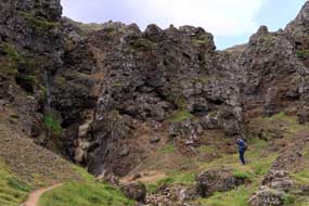
 Reykjadalur solfataras in the Hengill
geothermal zone:
a dull start but fine weather was forecast for today's walk up to the
Reykjadalur solfataras. Reserving our space again, we drove out beyond Hveragerði
to the road's end in lower Reykjadalur, where the parking area was already full and
over-spilling onto the approach road. The route crossed the Verma river to
ascend the slope on a broad, gravelly Reykjadalur solfataras in the Hengill
geothermal zone:
a dull start but fine weather was forecast for today's walk up to the
Reykjadalur solfataras. Reserving our space again, we drove out beyond Hveragerði
to the road's end in lower Reykjadalur, where the parking area was already full and
over-spilling onto the approach road. The route crossed the Verma river to
ascend the slope on a broad, gravelly path worn by the 1000s of visitors who
daily trudge up into the valley. On the far hill-side, the path followed a warm
stream issuing from hot-springs and steaming solfataras. It then passed a more
vigorously belching mud-pool, constantly bursting and filling the air with steam
reeking of hydrogen sulphide (see left). Now began an unremitting slog up the gravelly
path, winding around from the main valley and gaining 200m of height, followed
by another series of grinding ascents, dipping to cross a side beck, then up
again with startling views down into the depths of the Djúpagil gorge with the
spectacular cascade of a side torrent tumbling down to meet the main Reykjadalsá
river (see right). The mountain scenery surrounding the steep-sided gorge was
truly magnificent, but most of the tourists rushed on by in their haste to reach
the warm bathing pools higher upstream. path worn by the 1000s of visitors who
daily trudge up into the valley. On the far hill-side, the path followed a warm
stream issuing from hot-springs and steaming solfataras. It then passed a more
vigorously belching mud-pool, constantly bursting and filling the air with steam
reeking of hydrogen sulphide (see left). Now began an unremitting slog up the gravelly
path, winding around from the main valley and gaining 200m of height, followed
by another series of grinding ascents, dipping to cross a side beck, then up
again with startling views down into the depths of the Djúpagil gorge with the
spectacular cascade of a side torrent tumbling down to meet the main Reykjadalsá
river (see right). The mountain scenery surrounding the steep-sided gorge was
truly magnificent, but most of the tourists rushed on by in their haste to reach
the warm bathing pools higher upstream.
The path now dropped down into a wider valley,
where Icelandic horses which had ferried tourists up from the lower valley were
tethered (see left), and
 crossed the Reykjadalsá on a wooden footbridge for the final
section of ascent into upper Reykjadalur. Erosion damage to the path had been repaired with loose stone chippings, making for uncomfortable
walking. Before the warm water bathing pools of the main upper valley, the path
passed a series of violently active boiling springs and mud pools, with the
emergent boiling water and gases bubbling up and crossed the Reykjadalsá on a wooden footbridge for the final
section of ascent into upper Reykjadalur. Erosion damage to the path had been repaired with loose stone chippings, making for uncomfortable
walking. Before the warm water bathing pools of the main upper valley, the path
passed a series of violently active boiling springs and mud pools, with the
emergent boiling water and gases bubbling up and bursting forth surrounded by
clouds of evil-smelling steam (see right). The springs were now all safely fenced off to
prevent silly tourists scalding themselves. Beyond here, an even more unpleasant
sight sullied this marvellously strange natural landscape, with obese tourists
sprawled along the banks of the warm river-pools like Blackpool beach. We
dropped down to the river for a discrete ritual toe-dip to test the water
temperature: a comfortably warm 40ºC. Resuming the path, we continued further
into the upper valley of Klambragil, leaving behind the tourists wallowing in
the warm pools. The surrounding mountain-scape was severe with the scree-draped
craggy slopes of Molddalahnúkar rising sheer above us, and the valley head
enclosed by the cliff-face of Ölkelduhnúkur. The path continued ahead with an
utterly unforgiving grinding ascent up towards Nesjavellir. We branched off at
the foot of the steepest part of the ascent into the uppermost head of Reykjadalur
and the over-towering cliffs of Ölkelduhnúkur, heading over to another large
area of solfataras with its steaming bursting forth surrounded by
clouds of evil-smelling steam (see right). The springs were now all safely fenced off to
prevent silly tourists scalding themselves. Beyond here, an even more unpleasant
sight sullied this marvellously strange natural landscape, with obese tourists
sprawled along the banks of the warm river-pools like Blackpool beach. We
dropped down to the river for a discrete ritual toe-dip to test the water
temperature: a comfortably warm 40ºC. Resuming the path, we continued further
into the upper valley of Klambragil, leaving behind the tourists wallowing in
the warm pools. The surrounding mountain-scape was severe with the scree-draped
craggy slopes of Molddalahnúkar rising sheer above us, and the valley head
enclosed by the cliff-face of Ölkelduhnúkur. The path continued ahead with an
utterly unforgiving grinding ascent up towards Nesjavellir. We branched off at
the foot of the steepest part of the ascent into the uppermost head of Reykjadalur
and the over-towering cliffs of Ölkelduhnúkur, heading over to another large
area of solfataras with its steaming
 fumaroles (see left) (Photo
18 - Steaming fumaroles in upper Reykjadalur). At last today we could enjoy this wonderfully strange
unnatural landscape in peace, sharing the solitude with a few sheep which
clearly had no objection to grazing sulphur-tasting grass around the
steam-vents. The warm, steamy air attracted midges which swarmed around our
heads and cameras, but despite this we spent a happy hour photographing the boiling, steaming springs
and mud-pools, treading carefully over the fumaroles (see left) (Photo
18 - Steaming fumaroles in upper Reykjadalur). At last today we could enjoy this wonderfully strange
unnatural landscape in peace, sharing the solitude with a few sheep which
clearly had no objection to grazing sulphur-tasting grass around the
steam-vents. The warm, steamy air attracted midges which swarmed around our
heads and cameras, but despite this we spent a happy hour photographing the boiling, steaming springs
and mud-pools, treading carefully over the sulphur-encrusted hot ground. We
recalled similar boiling pools in the nearby Nesjavellir valley, passed during our 1972 climb of Hengill
and recorded on our rather grainy photograph taken 45 years ago, which is
paired
as a nostalgic time-lapse with
its 2017 equivalent taken today (Photo
19 - Reykjadalur boiling pool). We
followed the flow of the infant Reykjadalsá stream, past further hot springs and
mud-pots, into the enclosed gorge at the innermost recess of the valley head (see
below left).
Here the very beginnings of the Reykjadalsá trickled down the rocky chasm,
draining from marshes higher on Ölkelduháls mountain towering above (see right). This
wonderfully lonely spot, in such awe-inspiring mountainous surroundings, away
from the noise and banality of the tourist hordes wallowing in the warm
river-pools, marked today's highlight. sulphur-encrusted hot ground. We
recalled similar boiling pools in the nearby Nesjavellir valley, passed during our 1972 climb of Hengill
and recorded on our rather grainy photograph taken 45 years ago, which is
paired
as a nostalgic time-lapse with
its 2017 equivalent taken today (Photo
19 - Reykjadalur boiling pool). We
followed the flow of the infant Reykjadalsá stream, past further hot springs and
mud-pots, into the enclosed gorge at the innermost recess of the valley head (see
below left).
Here the very beginnings of the Reykjadalsá trickled down the rocky chasm,
draining from marshes higher on Ölkelduháls mountain towering above (see right). This
wonderfully lonely spot, in such awe-inspiring mountainous surroundings, away
from the noise and banality of the tourist hordes wallowing in the warm
river-pools, marked today's highlight.
 Beginning our return route, we followed the
course of the infant Reykjadalsá stream, as hot water from boiling springs and
mud-pools along its higher banks flowed in, heating the river water. This led us
across marshy ground to re-join the main path which circled around the left-hand
side of the now widening river. On the far side, steaming hot springs flowed
into the river warming it further, their mineral-rich water depositing and
encrusting the rocks with iron-red staining. At a path junction, we returned
along the far bank of the bathing pools, wading through tourist hordes as they
wallowed in the warm water. Re-crossing the river at the foot-bridge, we
re-joined the outward path for the return walk down-valley. With even greater
numbers of ill-clad, ill-shod tourists coming up the route, treading carelessly
causing further erosion to the ever-widening track, we returned along the main
path. The descent seemed even longer than the seemingly unending ascent, and on
the final lower section, we paused for further Beginning our return route, we followed the
course of the infant Reykjadalsá stream, as hot water from boiling springs and
mud-pools along its higher banks flowed in, heating the river water. This led us
across marshy ground to re-join the main path which circled around the left-hand
side of the now widening river. On the far side, steaming hot springs flowed
into the river warming it further, their mineral-rich water depositing and
encrusting the rocks with iron-red staining. At a path junction, we returned
along the far bank of the bathing pools, wading through tourist hordes as they
wallowed in the warm water. Re-crossing the river at the foot-bridge, we
re-joined the outward path for the return walk down-valley. With even greater
numbers of ill-clad, ill-shod tourists coming up the route, treading carelessly
causing further erosion to the ever-widening track, we returned along the main
path. The descent seemed even longer than the seemingly unending ascent, and on
the final lower section, we paused for further photos at the boiling mud-pools
hot-spot before completing the descent to the parking area. photos at the boiling mud-pools
hot-spot before completing the descent to the parking area.
Down into Hveragerði, we drove past the site of
the former spouting geyser Gryla, recalled from a gloomy day in 1972; it had
been blocked by the 2008 earthquake which hit Hveragerði and had
since then stopped spouting. On the way through the town, we paused to photograph
ripening strawberries in Hveragerði's geothermally heated greenhouses (see
right). Even in
1972, the town had been a noted fruit and vegetable growing place, full of greenhouses heated from Hengill geothermal sources. Back to Hveragerði Camping, we
settled in for our final night here, as the evening grew chill with a northerly
wind.
 Nesjavellir mountain walk from Dyrafjöll Pass:
overnight, George's interior temperature had been down to
10ºC, and this morning despite being bright, it was still chill. Traffic was
heavy on Route 1 as we headed east across the broad, flat coastal plain with the
bulky mass of the Ingólfsfjall table mountain rising clear ahead. As the road
skirted this mountainous plateau on the approach to Selfoss, the morning sun
highlighted all the details of lava crags on its southern cliff faces. Before
the Selfoss bridge over the broad and turbulent Ölfusá glacial river, we turned
off northwards onto Route 35 along the lower Ölfusá valley, running alongside
the eastern cliff-face of Ingólfsfjall (click
here for detailed map of route). Massive boulders and rock-fall
debris littered the fields at the foot of the cliffs. Just beyond the bridge
crossing the Sog River flowing from Þingvallavatn to its confluence with the Ölfusá,
we entered a vast area of birch scrubland around the shores of Álftavatn, riddled
with the summer Nesjavellir mountain walk from Dyrafjöll Pass:
overnight, George's interior temperature had been down to
10ºC, and this morning despite being bright, it was still chill. Traffic was
heavy on Route 1 as we headed east across the broad, flat coastal plain with the
bulky mass of the Ingólfsfjall table mountain rising clear ahead. As the road
skirted this mountainous plateau on the approach to Selfoss, the morning sun
highlighted all the details of lava crags on its southern cliff faces. Before
the Selfoss bridge over the broad and turbulent Ölfusá glacial river, we turned
off northwards onto Route 35 along the lower Ölfusá valley, running alongside
the eastern cliff-face of Ingólfsfjall (click
here for detailed map of route). Massive boulders and rock-fall
debris littered the fields at the foot of the cliffs. Just beyond the bridge
crossing the Sog River flowing from Þingvallavatn to its confluence with the Ölfusá,
we entered a vast area of birch scrubland around the shores of Álftavatn, riddled
with the summer houses of Reykjavík's nouveaux-riches. Every driveway had
security gates and cameras; even in Iceland, privacy and security came with a
price tag! We turned off onto Route 36 through the heart of this birch-scrub
summer houses estate, and along the lower Sog valley past the distinctive
volcanic peak of Burfell. At Ljósafossstöð, where the Sog flowing from
Úlfljótsvatn is dammed for an HEP generating station, we turned off again onto
Route 360. The road passed Iceland's main Scouting campsite at Úlfljótsvatn,
which is open to public usage but at astronomically unreal prices. The road now
became unsurfaced for some 12kms across farmland and lava fields, passing
Hagavík Bay, an inlet of the huge 84 square kilometres lake of Þingvallavatn.
The bumpy, corrugated gravel road crossed the Nesjahraun lava field, an ancient
northward outflowing of the Hengill and Nesjavellir volcanoes, to reach the evil-looking, evil-smelling geothermal watercourse emerging from the Nesjavellir houses of Reykjavík's nouveaux-riches. Every driveway had
security gates and cameras; even in Iceland, privacy and security came with a
price tag! We turned off onto Route 36 through the heart of this birch-scrub
summer houses estate, and along the lower Sog valley past the distinctive
volcanic peak of Burfell. At Ljósafossstöð, where the Sog flowing from
Úlfljótsvatn is dammed for an HEP generating station, we turned off again onto
Route 360. The road passed Iceland's main Scouting campsite at Úlfljótsvatn,
which is open to public usage but at astronomically unreal prices. The road now
became unsurfaced for some 12kms across farmland and lava fields, passing
Hagavík Bay, an inlet of the huge 84 square kilometres lake of Þingvallavatn.
The bumpy, corrugated gravel road crossed the Nesjahraun lava field, an ancient
northward outflowing of the Hengill and Nesjavellir volcanoes, to reach the evil-looking, evil-smelling geothermal watercourse emerging from the Nesjavellir
 geothermal power station just along the valley, whose clouds of steam filled the
air. Just beyond, we turned off onto the Route 435 mountain road which zigzagged
its way, climbing at a 15% gradient over Dyrafjöll's high volcanic ridges running northwards from Hengill. As we climbed the steep hair-pins, high pressure
steam pipes snaked downhill from bore-hole well-heads feeding the Nesjavellir
geothermal power plant down in the valley bottom. The
Rother Guide to Iceland
(Route 60)
described a way-marked 5kms circular walking route around the volcanic
hills of Nesjavellir which we planned to follow today. Rounding the last of the
series of hair-pins, passing side-turnings leading down to bore-hole well-heads,
and climbing further alongside steam feeder-pipelines (see above left), we pulled into the walk's
start-point at a parking area by huge hot water storage-tanks at the summit of the Dyrafjöll Pass. geothermal power station just along the valley, whose clouds of steam filled the
air. Just beyond, we turned off onto the Route 435 mountain road which zigzagged
its way, climbing at a 15% gradient over Dyrafjöll's high volcanic ridges running northwards from Hengill. As we climbed the steep hair-pins, high pressure
steam pipes snaked downhill from bore-hole well-heads feeding the Nesjavellir
geothermal power plant down in the valley bottom. The
Rother Guide to Iceland
(Route 60)
described a way-marked 5kms circular walking route around the volcanic
hills of Nesjavellir which we planned to follow today. Rounding the last of the
series of hair-pins, passing side-turnings leading down to bore-hole well-heads,
and climbing further alongside steam feeder-pipelines (see above left), we pulled into the walk's
start-point at a parking area by huge hot water storage-tanks at the summit of the Dyrafjöll Pass.
 Despite the forecast for clear weather, here in
these high volcanic hills it had now turned overcast with squally showers. As
these blew over, we kitted up and had just started up the way-marked turf
path, when a car stopped on the road just below us. A lady called out from the
car: Hello, she said, we met you recently at Núpur Guest-house. Not recognising
the couple at first, we must have looked blankly vacant, but she insisted that we had
spoken with them while cooking supper in the kitchen at Núpur. We suddenly
recalled the meeting over 4 weeks and many adventures ago when we had camped at Núpur in the West Fjords (See
log of our camp at Núpur). The couple had a summer house at Þingvallavatn, and
were just returning home to Reykjavík; they must have recognised George at the
head of pass parking area and turned back to greet us. This was yet another of
those remarkably serendipitous coincidences that add lustre to our travels. Despite the forecast for clear weather, here in
these high volcanic hills it had now turned overcast with squally showers. As
these blew over, we kitted up and had just started up the way-marked turf
path, when a car stopped on the road just below us. A lady called out from the
car: Hello, she said, we met you recently at Núpur Guest-house. Not recognising
the couple at first, we must have looked blankly vacant, but she insisted that we had
spoken with them while cooking supper in the kitchen at Núpur. We suddenly
recalled the meeting over 4 weeks and many adventures ago when we had camped at Núpur in the West Fjords (See
log of our camp at Núpur). The couple had a summer house at Þingvallavatn, and
were just returning home to Reykjavík; they must have recognised George at the
head of pass parking area and turned back to greet us. This was yet another of
those remarkably serendipitous coincidences that add lustre to our travels.
 The path sloped up the fell-side of Kýrdalshryggur
ridge, passing alongside wonderful, jagged slatey lava formations, and emerging onto
the side-crest of the ridge. By now the sky had cleared and sun was shining,
lighting the moss-covered lava hills on the far side of Nesjavellir valley. In
the northern distance, Þingvallavatn showed up clear blue in the sunlight, the
lake dotted with islands (Photo
20 - Þingvallavatn from Nesjavellir) (see above right).
Way down below us along the length of Nesjavellir
valley, dome-covered well-heads were dotted along Kýradalur valley floor,
connected by pipe-lines feeding the high pressure geothermal steam to Nesjavellir power station whose columns of exhaust steam billowed in the air. We gained more
height along the crest of the ridge-line, reaching a paths junction where one
route dropped down leftwards into Nesjavellir valley (see above left); our path continued upwards along
the crest of Kýrdalshryggur ridge to reach this route's high-point at 460m.
Ahead the ridge became impassably craggy on the heights of Vörðuskeggi, part of
the outlying northern peaks of Hengill. Our on-going path, clearly way-marked
with green-topped pegs, crossed the ridge-line of Kýrdalshryggur and began a
sloping descent into the lushly green, deserted valley of Skeggjadalur (Photo
21 - Peaceful Skeggjadalur) (see left and above right). For only the
second time in 3 months, we had the privilege of enjoying the peace of these
wonderfully wild mountains The path sloped up the fell-side of Kýrdalshryggur
ridge, passing alongside wonderful, jagged slatey lava formations, and emerging onto
the side-crest of the ridge. By now the sky had cleared and sun was shining,
lighting the moss-covered lava hills on the far side of Nesjavellir valley. In
the northern distance, Þingvallavatn showed up clear blue in the sunlight, the
lake dotted with islands (Photo
20 - Þingvallavatn from Nesjavellir) (see above right).
Way down below us along the length of Nesjavellir
valley, dome-covered well-heads were dotted along Kýradalur valley floor,
connected by pipe-lines feeding the high pressure geothermal steam to Nesjavellir power station whose columns of exhaust steam billowed in the air. We gained more
height along the crest of the ridge-line, reaching a paths junction where one
route dropped down leftwards into Nesjavellir valley (see above left); our path continued upwards along
the crest of Kýrdalshryggur ridge to reach this route's high-point at 460m.
Ahead the ridge became impassably craggy on the heights of Vörðuskeggi, part of
the outlying northern peaks of Hengill. Our on-going path, clearly way-marked
with green-topped pegs, crossed the ridge-line of Kýrdalshryggur and began a
sloping descent into the lushly green, deserted valley of Skeggjadalur (Photo
21 - Peaceful Skeggjadalur) (see left and above right). For only the
second time in 3 months, we had the privilege of enjoying the peace of these
wonderfully wild mountains without the intrusion of milling hordes of tourists; we shared this secret hidden high valley into which we now descended
with just a couple of grazing sheep, arguably more intelligent company than the
gormless tourists! Crossing the valley floor, we dropped down into a further
hidden valley, enclosed on 3 sides by lava hills. A track-way into the
valley-head suggested the area was used for upland grazing. Thankful for the
way-markings, we crossed this subsidiary valley and descended the craggy side of Sponhelldalir into a rough watercourse, dry at this time of year. The
route dropped down a steep, rough slope amid craggy lava, and ahead the road
over Dyrafjöll Pass was visible. Negotiating another rough slope brought
alongside a sheer wall of lava across black volcanic gravel up to the road. without the intrusion of milling hordes of tourists; we shared this secret hidden high valley into which we now descended
with just a couple of grazing sheep, arguably more intelligent company than the
gormless tourists! Crossing the valley floor, we dropped down into a further
hidden valley, enclosed on 3 sides by lava hills. A track-way into the
valley-head suggested the area was used for upland grazing. Thankful for the
way-markings, we crossed this subsidiary valley and descended the craggy side of Sponhelldalir into a rough watercourse, dry at this time of year. The
route dropped down a steep, rough slope amid craggy lava, and ahead the road
over Dyrafjöll Pass was visible. Negotiating another rough slope brought
alongside a sheer wall of lava across black volcanic gravel up to the road.
 By now cloud had gathered again and rain was
beginning. Our on-going route crossed the road to mount a grassy slope, as a
mini-bus pulled into the lay-by, dropping off a bevy of walkers who followed us
up the slope. Emerging into another world of lava-encrusted crests, ridges and northward-facing valleys
(see left), we waited for the group to pass, their rowdy noise an
unwelcome intrusion into the peace of the hills. The peg-markers now led across
the jagged red lava which enclosed the high head of the valley and up the slope
on the far side. As we gained height, the squall passed and sky began to
brighten. The path passed further slabs of lava, and in the better light, the
views looking south across the lava ridges over towards the Hengill massif were
totally thrilling (see above right); again we were able to appreciate this mountainous beauty in
peaceful solitude. The path rounded another crumbly lava valley-head, and sloped
up and over a spur to descend to a further hollow. Here at a trail junction we
turned off eastwards to mount a steep, black scoria slope onto the final
high-point to reach a radio mast. From here we could look down into Nesjavellir
valley again, with steam rising from the power plant and its effluent stream
running down towards Þingvallavatn. From here a stony track-way led back to the
water-tanks parking area By now cloud had gathered again and rain was
beginning. Our on-going route crossed the road to mount a grassy slope, as a
mini-bus pulled into the lay-by, dropping off a bevy of walkers who followed us
up the slope. Emerging into another world of lava-encrusted crests, ridges and northward-facing valleys
(see left), we waited for the group to pass, their rowdy noise an
unwelcome intrusion into the peace of the hills. The peg-markers now led across
the jagged red lava which enclosed the high head of the valley and up the slope
on the far side. As we gained height, the squall passed and sky began to
brighten. The path passed further slabs of lava, and in the better light, the
views looking south across the lava ridges over towards the Hengill massif were
totally thrilling (see above right); again we were able to appreciate this mountainous beauty in
peaceful solitude. The path rounded another crumbly lava valley-head, and sloped
up and over a spur to descend to a further hollow. Here at a trail junction we
turned off eastwards to mount a steep, black scoria slope onto the final
high-point to reach a radio mast. From here we could look down into Nesjavellir
valley again, with steam rising from the power plant and its effluent stream
running down towards Þingvallavatn. From here a stony track-way led back to the
water-tanks parking area
Selfoss Camping:
we now had the return drive back down to Selfoss where we planned to camp
tonight in readiness for George's appointment on Monday to have the replacement
temperature sensor fitted. Returning down the Dyrafjöll Pass hair-pins showed
just how steep the road was, passing the turns down to the geothermal steam
well-heads. Back round past the power plant's steaming effluent ponds, we
returned around the section of unsurfaced road with the sky gloomy and rain
beginning again. Beyond Ljósafossstöð, Route 36 brought us back along the lower Ölfusá
valley to the Ring Road which was now busy with Reykjavík holiday weekenders
returning home. Crossing the Ölfusá on the Selfoss suspension bridge showed what
a wide and furious river this was, turquoise-grey with all the glacial sediment.
Route 1 passed through the heart of Selfoss, and part-way through we turned off
to find the campsite by the Selfoss sports ground in the midst of a residential
area but overlooking birch-wooded lava fields. We had not planned to use this
campsite since its website suggested it was unduly expensive, but we needed to
be local for tomorrow's temperature sensor fitting. A phone call earlier had in
fact confirmed a significant seniors' discount: 1,250kr/person plus 500kr for
power making a total of 3,000kr seemed far more reasonable compared with Hveragerði's
unduly expensive pricing. The camping area was large, grassy and flat, but
almost empty on a Sunday evening after all the weekenders had left. We pitched
over on the far side looking onto the birch-wood covered lava field, and the
evening grew dark, gloomy and miserably chill.
A more typical good VW service at Selfoss:
we were up early ready to depart at 9-30am to drive around to the industrial area
on the town's outskirts to find the Klettur ehf VW garage. Before leaving
Selfoss Camping, we had phoned to confirm the arrangement for fitting George's
sensor; the man answering assured us the part would be fitted as soon as we
arrived to avoid a wait. In contrast with the glitzy but utterly dysfunctional
Hekla showroom-garage in Reykjavík, Klettur the Selfoss VW agent was a small but
genuine garage-workshop. Here was a working garage, staffed by mechanics (not a
suit in sight!); the senior mechanic knew all about what was needed, greeted us
by name and summoned a mechanic to fit the replacement sensor. He laughed as he
realised that George's steering wheel was 'on the wrong side'! But
potential disaster: Hekla had not only supplied the wrong part, but over-charged
us. Fortunately Klettur had the correct part for a VW T4 in stock, and 5 minutes
later this was duly fitted; not only that, but the kindly man volunteered to
recompense us and recover the over-charge from Hekla. This was more like the
genuine VW standard of service we had customarily enjoyed all across Europe. So
by 10-15am, with his new temperature sensor fitted and gauge now duly working,
George drove us back into Selfoss, all thanks to such excellent service from the
staff at Klettur ehf who fully deserve our thanks and praise; this in stark
contrast with the total absence of service at the glitzy
but utterly incompetent Helka garage in Reykjavík, who deserve to lose their VW
accreditation.
Selfoss, a graceless service centre town:
Selfoss, the largest town in Southern Iceland with 4,000 inhabitants, is
described not inaccurately as an unremittingly graceless service centre town. It
grew up around the original British-engineered suspension bridge built in 1891
to span the wild Ölfusá river. Before that, all traffic through the
region had to cross this treacherous glacial river by ferry further south
towards the river's estuary where the rough water made crossings hazardous. The
bridge was an immediate success, and became the focus for Selfoss' development
as a trading centre. The current bridge dates from 1945, after the original one
collapsed when 2 milk takers tried to cross simultaneously! Our only reason for
coming into such a functional service centre as Selfoss, had been to have the
new sensor fitted at Klettur and to re-stock with provisions. We had completed
the first of these, now turned our attention to the second. Between the town's 3
supermarkets along the Ring Road through Selfoss, we re-stocked with 3 days'
supply of provisions.
Þorlákshöfn, Eyrarbakki and Stokkseyri on
Iceland's south coast:
today and tomorrow were both forecast for grim, wet weather, so that we had
re-scheduled our programme to spend these days down at the south coast at Þorlákshöfn, Eyrarbakki and Stokkseyri,
with a rest day tomorrow before picking up our programme at Þingvellir on
Wednesday. By the time we had completed our shopping in Selfoss, not only was it
pouring with rain, but grey, very wet misty rain cloud totally enveloped the
town, Ingólfsfjall and the entire southern coastal plain. It was now a
thoroughly wet and miserable day, with nothing of the flat coastal plain visible
in the enveloping misty rain cloud, as we drove the 12 kms on Route 34 down to
the south coast (click
here for detailed map of route). We had hoped to spend a couple of hours
at the Flói Wetlands Bird Reserve on the shore of the Ölfusá estuary, but in
such wretched weather, this was hopeless. Passing Eyrarbakki, we crossed the Ölfusá
estuary bridge and sandspit causeway westwards along to the modern industrial
fishing port of Þorlákshöfn. The gloomy weather made this functional little
port-town seem even more dreary. Sheltering from the rain, we sat in George to
eat our lunch sandwiches by the frozen fish factory, looking out through the
mist across the docks, then drove along past the port where new vehicles
imported from Europe stood in compounds. The ferry out to the Westman
Islands used to sail from Þorlákshöfn, but now takes the shorter crossing from
Landeyjahöfn further east unless winter weather is too rough. Before leaving, we
investigated the Þorlákshöfn campsite, another of those municipal sites with
showers at extra cost in the next door swimming pool, but well sheltered behind
embankments from
the wind.
With the weather still misty and wet, we returned
along to Eyrarbakki; this once busy fishing and trading port is now a quiet
backwater. Until the early 20th century, it was a thriving commercial centre and
port, with boats dragged up on the beach from the surging Atlantic surf which
batters the coast. But as motorised boats became too big for this, trade moved
westwards to the newer industrial port of Þorlákshöfn, leaving neighbouring
Eyrarbakki as a rather has-been place. It was from Eyrarbakki that in 985 AD
Bjarni Herjölfsson sailed west aiming for Greenland. But he was blown off course
in a storm and became truly the first European to sight the North American
continent. But displaying a misguided lack of vision, he failed to land and
returned to Greenland. Here he told his tale of sighting new lands and sold his
boat to Leifur Eiríksson, who re-traced the route, made landfall and named the
place Vinland, so earning his place in history instead of the now unknown Bjarni
Herjölfsson of Eyrarbakki. Today, Eyrarbakki's main employer is Iceland's
largest prison which stands in the village outskirts surrounded by double
security fencing. We stopped off at Eyrarbakki's TIC, where the feckless girl
was scarcely capable of giving out brochures; she had clearly never even heard
of the Flói Bird Reserve, despite it being in the village outskirts and
Eyrarbakki's virtually only worthwhile feature. We did manage to find a map of
the coastal villages, and climbed up onto the coastal defence-embankment to look
out over the dreary beach from where boats were once launched by dragging them
down through the Atlantic surf to be rowed out into deeper waters
 We continued eastwards to the similarly has-been
former fishing village of Stokkseyri. Both villages have tried to resurrect
their livelihoods from tourism by using once functional, now redundant
buildings to house a range of quirky museums and over-priced restaurants, with
mixed degree of success. One genuine local industry still surviving is
Björgvin Tómasson, Iceland's only organ builder,
based in part of Stokkseyri's old fish processing factory. We stopped by to
investigate but regrettably the premises were closed. We continued eastwards to the similarly has-been
former fishing village of Stokkseyri. Both villages have tried to resurrect
their livelihoods from tourism by using once functional, now redundant
buildings to house a range of quirky museums and over-priced restaurants, with
mixed degree of success. One genuine local industry still surviving is
Björgvin Tómasson, Iceland's only organ builder,
based in part of Stokkseyri's old fish processing factory. We stopped by to
investigate but regrettably the premises were closed.
A wet day in camp at Stokkseyri Camping:
all three villages had campsites, but Stokkseyri's seemed best value with
seniors' reduction of 700kr/person and 700kr for power; at 2,100kr total, it was
one of the best campsite prices in Iceland, and also accepted the camping card.
The open, wind-swept camping area without shelter was set on the dull, flat coastal plain, with
distant misty views of the inland mountains, and we settled in for an
afternoon's work. The rain eased but the sky remained sullen grey and air
moist, with Ingólfsfjall scarcely visible. Early evening, the cheery lady called
round for payment, and we used the 23rd of the 28 slots on our camping card;
considering the remaining sites, it looked as if we should manage to use all our
card's capacity after all. With a thoroughly wet day forecast for tomorrow, we should take
a day in camp here at Stokkseyri. It rained most of the night, and the following
morning the sky was still heavily overcast with gusty wind blowing rain into the
sliding door. After breakfast, we moved George round 180º, but the forecast
continuous rain failed to materialise, and although inland the sky remained
gloomily dark, at least along the coast it brightened during the afternoon.
Stokkseyri was a good value, well-equipped municipal site with newly upgraded
facilities, and being off the main tourist route, not unduly busy; it had served
us well and we rated it at +4.
 Flói Wetlands Bird Reserve: the following morning was bright and
sunny with early sunlight picking out all the details of the southern face of
distant Ingólfsfjall (see above left).
But as in the other Nordic countries, mid-August marked the beginnings of
autumn, although in Iceland there were no trees to turn golden; after a chill
night, George's windows were streaming this morning with condensation. We were
away early, and having re-filled George's fresh water tank, we turned off beyond Eyrarbakki
along a gravel drive-way to the
Flói Bird Reserve
out in Flói Wetlands Bird Reserve: the following morning was bright and
sunny with early sunlight picking out all the details of the southern face of
distant Ingólfsfjall (see above left).
But as in the other Nordic countries, mid-August marked the beginnings of
autumn, although in Iceland there were no trees to turn golden; after a chill
night, George's windows were streaming this morning with condensation. We were
away early, and having re-filled George's fresh water tank, we turned off beyond Eyrarbakki
along a gravel drive-way to the
Flói Bird Reserve
out in the wetlands of the Ölfusá estuary. 3kms along
past farmsteads, we reached the parking area and bird-hide. The Flói Bird Reserve
was set up in 1997 from former drained meadowland which had been allowed to
revert to its natural state of flooded wetlands. The Flói area is part of the
Great Þjórsá lava field, one of world's largest post-Glacial lava flows, 26m deep
and covering ca 970 square kms, originating from an inland eruption some 8,500
years ago which covered Southern Iceland. Depressions in the ancient lava filled
with water from the local high water table to form shallow pools covering the
wetlands which are now home to many bird species, particularly waders and Red
Throated Divers, all of which breed widely at Flói. As we parked at the hide, a
chubby, speckled Meadow Pipit
(Photo
22 - Meadow Pipit) (see left) and a Wheatear (Photo
23 - Wheatear) (see right) perched on the fence in front of a
pool, but that was about all we could see. We set off to walk the circuit around
the meadowland reserve which would normally need wellies for access; today
however the pools and peat were quite dry, and as a result there was no
bird-life to be seen at this time of year, other than hearing the the wetlands of the Ölfusá estuary. 3kms along
past farmsteads, we reached the parking area and bird-hide. The Flói Bird Reserve
was set up in 1997 from former drained meadowland which had been allowed to
revert to its natural state of flooded wetlands. The Flói area is part of the
Great Þjórsá lava field, one of world's largest post-Glacial lava flows, 26m deep
and covering ca 970 square kms, originating from an inland eruption some 8,500
years ago which covered Southern Iceland. Depressions in the ancient lava filled
with water from the local high water table to form shallow pools covering the
wetlands which are now home to many bird species, particularly waders and Red
Throated Divers, all of which breed widely at Flói. As we parked at the hide, a
chubby, speckled Meadow Pipit
(Photo
22 - Meadow Pipit) (see left) and a Wheatear (Photo
23 - Wheatear) (see right) perched on the fence in front of a
pool, but that was about all we could see. We set off to walk the circuit around
the meadowland reserve which would normally need wellies for access; today
however the pools and peat were quite dry, and as a result there was no
bird-life to be seen at this time of year, other than hearing the
 distant call
of a Diver. The irony was that during the June breeding season, when many birds
would be seen on the ponds, access would have been far more difficult because
of the wetlands; today in much drier conditions making walking access easy,
there was nothing to be seen. distant call
of a Diver. The irony was that during the June breeding season, when many birds
would be seen on the ponds, access would have been far more difficult because
of the wetlands; today in much drier conditions making walking access easy,
there was nothing to be seen.
Ljóssafoss hydro-power station exhibition
centre: back up the lane
to Selfoss, we shopped for 3 further days' supplies before driving north again
along the lower Ölfusá valley under the shadow of Ingólfsfjall's mighty eastern
cliffs and rock-fall debris (click
here for detailed map of route). Across the birch-scrub summer houses
estate, past Burfell, we reached the hydro-electric generating station at
Ljóssafoss which exploits the dammed outflow of Úlfljótsvatn (see left). We parked and
walked across the Sog River bridge in search of water birds, said to include
Barrow's Goldeneye; but today nothing. The Ljóssafoss
hydro-electric generating station just below the dam is the oldest of the 3 HEP
stations on the Sog, and opened in 1937 to provide domestic electricity for
Reykjavík (see right). The national power company, Landsvirkjun, provides an educational
exhibition at Ljóssafossstöð; although aimed primarily at children, the
interactive displays proved to be thoroughly interesting, showing Iceland's
power consumption usage, both domestic and industrial, generated totally from
renewable sources, 30% geothermal and 70% hydro-generated. We also learned from
the staff manning the exhibition how to pronounce the Icelandic double-ll, as in
Þingvellir, pronounced as Thing-vedd-lir, almost like the Welsh double-ll. (click
here for detailed map of route). Across the birch-scrub summer houses
estate, past Burfell, we reached the hydro-electric generating station at
Ljóssafoss which exploits the dammed outflow of Úlfljótsvatn (see left). We parked and
walked across the Sog River bridge in search of water birds, said to include
Barrow's Goldeneye; but today nothing. The Ljóssafoss
hydro-electric generating station just below the dam is the oldest of the 3 HEP
stations on the Sog, and opened in 1937 to provide domestic electricity for
Reykjavík (see right). The national power company, Landsvirkjun, provides an educational
exhibition at Ljóssafossstöð; although aimed primarily at children, the
interactive displays proved to be thoroughly interesting, showing Iceland's
power consumption usage, both domestic and industrial, generated totally from
renewable sources, 30% geothermal and 70% hydro-generated. We also learned from
the staff manning the exhibition how to pronounce the Icelandic double-ll, as in
Þingvellir, pronounced as Thing-vedd-lir, almost like the Welsh double-ll.
 Passing the Ljóssafoss dam (see below left), we began the 12kms gravel road around
the shores of Úlfljótsvatn and southern Þingvallavatn, to reach the
steaming outflow of Nesjavellir geothermal power station and the solfataras
higher up the valley on the northern slopes of Hengill (see below right). We later concluded that
in 1972 we had wild-camped somewhere just along the western shore of Þingvallavatn,
as the base from which to climb Hengill up through the solfataras, long before
the power station was built. Passing the turning where Route 435 climbed over
the Dyrafjöll Pass, today we continued ahead on Route 360 with the narrow road Passing the Ljóssafoss dam (see below left), we began the 12kms gravel road around
the shores of Úlfljótsvatn and southern Þingvallavatn, to reach the
steaming outflow of Nesjavellir geothermal power station and the solfataras
higher up the valley on the northern slopes of Hengill (see below right). We later concluded that
in 1972 we had wild-camped somewhere just along the western shore of Þingvallavatn,
as the base from which to climb Hengill up through the solfataras, long before
the power station was built. Passing the turning where Route 435 climbed over
the Dyrafjöll Pass, today we continued ahead on Route 360 with the narrow road winding a way along the western shore of Þingvallavatn which now looked grey
from the cloud which had replaced the sun of earlier. We passed several spots
just off the road where we might have wild-camped in 1972, although the number
of summer houses along the lake shores had inevitably increased over the years. The road
shelved above the lake, finally meeting the junction with Route 36 from
Reykjavík to Þingvellir, and turned north-east to reach the Þingvellir Visitor Centre.
winding a way along the western shore of Þingvallavatn which now looked grey
from the cloud which had replaced the sun of earlier. We passed several spots
just off the road where we might have wild-camped in 1972, although the number
of summer houses along the lake shores had inevitably increased over the years. The road
shelved above the lake, finally meeting the junction with Route 36 from
Reykjavík to Þingvellir, and turned north-east to reach the Þingvellir Visitor Centre.
The historical significance of Þingvellir: as
expected, depressing numbers of tourist cars and tour-buses filled the Þingvellir
car park which now charged 500kr/day. The so-called Visitor Centre was little
more than a glorified tourist souvenir shop, its only pretence at information
provision about the National Park being the showing of a video on the historical,
cultural and geological significance of the Þingvellir rift-valley.
From the late 9th~beginning of 10th century
Settlement, Iceland's 36 regional chieftains (goðar) were meeting at
local assemblies (things) to settle disputes and determine laws. But as
the new country became more established, the need was recognised for some form
of national assembly. Having fled a tyrannical kingdom in Norway, the
Icelandic settlers were resolved on a system of governance based not on monarchy but rather a Commonwealth (Þjóðveldið). From 930 AD, the plain of
the Þingvellir rift-valley was chosen as a convenient
 central meeting point of
overland routes from around the country for a General Assembly (Alþing),
to be held for 2 weeks each summer, where the chieftains accompanied by their
retainers gathered, setting up their tents (buðs), to decide national
laws and dispense justice as a central court. The clan chieftains together
formed the legislative and judicial body, the Law Council (Lögrétta).
Proceedings of the Alþing and the Council were regulated by the
Lawspeaker (Lögsögumaður), selected from among the chieftains for a term
of 3 years; before the days of general literacy, it was his responsibility to know and to recite the laws. This
sophisticated system of government encouraged lively political debate and
allowed for total transparency, as all free men attending the Alþing were
able to listen openly to proceedings and to put arguments to the assembly from
the Law Rock (Lög Berg), the raised rocky podium overlooking the Þingvellir
amphitheatre. In a new country, divided by distance and harsh weather, the
annual summer gathering at Þingvellir enabled the scattered communities to meet and
to interact: marriages were arranged, alliances forged, trade was conducted; the
settlers became a nation at Þingvellir. central meeting point of
overland routes from around the country for a General Assembly (Alþing),
to be held for 2 weeks each summer, where the chieftains accompanied by their
retainers gathered, setting up their tents (buðs), to decide national
laws and dispense justice as a central court. The clan chieftains together
formed the legislative and judicial body, the Law Council (Lögrétta).
Proceedings of the Alþing and the Council were regulated by the
Lawspeaker (Lögsögumaður), selected from among the chieftains for a term
of 3 years; before the days of general literacy, it was his responsibility to know and to recite the laws. This
sophisticated system of government encouraged lively political debate and
allowed for total transparency, as all free men attending the Alþing were
able to listen openly to proceedings and to put arguments to the assembly from
the Law Rock (Lög Berg), the raised rocky podium overlooking the Þingvellir
amphitheatre. In a new country, divided by distance and harsh weather, the
annual summer gathering at Þingvellir enabled the scattered communities to meet and
to interact: marriages were arranged, alliances forged, trade was conducted; the
settlers became a nation at Þingvellir.
 On the advice of Lawspeaker Þorgeir Þorkelsson,
the Alþing agreed to adopt Christianity in 1000 AD as the new nation's
universal religion to resolve the civil strife between pagan and Christian
factions. But as time went on, the Alþing's authority was undermined by
its lack of power to enforce court decisions and penalties. After the 13th
century period of civil strife between rival clan chieftains, the Icelanders had
no other choice but to accept the sovereignty of the Norwegian and later Danish
monarchy, with the signing of the Old Covenant in 1262; the country was forced
to adopt the
Norwegian Járnsiða law code, and although the Alþing survived, its
authority declined. It
lost its legislative powers, became little more than a national court, and was
abolished in 1798. Þingvellir became a focus of the Icelandic nationalist
movement during the 19th century, and the celebrations of Iceland's millennium
were held at Þingvellir in 1874 when Danish King Christian IX delivered a
constitution for the country. The place remained a symbol of national identity
during the 20th century, culminating in the declaration of the Republic of
Iceland's independence on 17 June 1944 at Þingvellir. And today, 1000s of
tourists daily mill around the site at Þingvellir, most of them totally
oblivious to its historical and cultural significance for Icelanders. On the advice of Lawspeaker Þorgeir Þorkelsson,
the Alþing agreed to adopt Christianity in 1000 AD as the new nation's
universal religion to resolve the civil strife between pagan and Christian
factions. But as time went on, the Alþing's authority was undermined by
its lack of power to enforce court decisions and penalties. After the 13th
century period of civil strife between rival clan chieftains, the Icelanders had
no other choice but to accept the sovereignty of the Norwegian and later Danish
monarchy, with the signing of the Old Covenant in 1262; the country was forced
to adopt the
Norwegian Járnsiða law code, and although the Alþing survived, its
authority declined. It
lost its legislative powers, became little more than a national court, and was
abolished in 1798. Þingvellir became a focus of the Icelandic nationalist
movement during the 19th century, and the celebrations of Iceland's millennium
were held at Þingvellir in 1874 when Danish King Christian IX delivered a
constitution for the country. The place remained a symbol of national identity
during the 20th century, culminating in the declaration of the Republic of
Iceland's independence on 17 June 1944 at Þingvellir. And today, 1000s of
tourists daily mill around the site at Þingvellir, most of them totally
oblivious to its historical and cultural significance for Icelanders.
The geological significance of Þingvellir: just beyond the Visitor Centre, a
huge wooden platform set at the highest point of the Almannagjá Gorge forms a
lookout point showing the wonder and stark beauty of Þingvellir's geology and
topography: panoramic views open out along the length of this huge fissure,
and across the 5km wide lava field plain of rift valley depression, flanked by
the volcanic peaks of Ármannsfell and Hrafnabörg at the northern end, and
southwards towards Þingvallavatn (see above left). Þingvellir is set directly on the line of the
divergent American and European tectonic plates boundary, the Mid-Atlantic
Ridge, which is widening at the rate of 2cms/year. The rifting zone at Þingvellir
forms the northern part of the Hengill volcanic system which reaches from the
sea in the SW 130kms long and up to 20kms wide, inland up to Skaldbreiður shield
volcano
(see right). Tension in the earth's crust along the line of the tectonic plates,
pulling apart in opposite directions, has resulted in the widening rift valley (graben)
at Þingvellir, causing faults, fissures or more violent earthquakes ripping
through the bed rock, like stretch-marks in the landscape. More than 100 faults
and open fissures can be seen across the 5km width of Þingvellir's depression. Over the past 10,000
years, the diverging Þingvellir valley floor rift between the huge fault-fissures of Almannagjá
on the western (American) side and Hrafnagjá on the eastern (European) side has
subsided by some 40m. The extent of the depression can be judged
 by comparing
the height of the Kerlingarhraun lava field to the west of Almannagjá's top
edge above the Öxarárfoss waterfall, with the valley floor below. 10,000 years
ago, high volumes of fluid lava in steady, continuous rather than violent
explosive eruptions, flowed down the rift valley from the massive shield volcano
of Skaldbreiður. 9,000 years ago, further lava flows blocked off the outflow of
springs, back-filling to form the 14kms long Þingvallavatn and its sole outflow,
the River Sog. by comparing
the height of the Kerlingarhraun lava field to the west of Almannagjá's top
edge above the Öxarárfoss waterfall, with the valley floor below. 10,000 years
ago, high volumes of fluid lava in steady, continuous rather than violent
explosive eruptions, flowed down the rift valley from the massive shield volcano
of Skaldbreiður. 9,000 years ago, further lava flows blocked off the outflow of
springs, back-filling to form the 14kms long Þingvallavatn and its sole outflow,
the River Sog.
A contrast in conditions at Þingvellir in the
45 years between 1972 and 2017:
with the weather becoming increasingly overcast and rain threatening, we
contented ourselves today with getting the lie of the land in readiness for a
more thorough exploration in the better weather forecast for tomorrow. As we
stood at the viewpoint atop the Almannagjá Gorge looking out across the rift
valley to the equivalent fissure of Hrafnagjá on the far side of the Þingvallahraun lava fields
spread out below, it was clear that Þingvellir showed the starkest contrast in
the last 45 years between our first visit in 1972 and the conditions today in
2017. We stood there desperately trying to reconcile all the formalised tourist
infrastructure of today with the undisturbed natural setting which we had
witnessed in 1972. It was impossible; so much had changed, except of course the
stark natural beauty of the landscape. Again we have
paired our photo taken today at Þingvellir with its
equivalent photo taken 45 years ago (Photo
24- Þingvellir 2017 and 1972) (see left).
45 years ago in 1972, we could recall seeing few
other visitors; there were no restrictions on access, no formally laid out
paths, and we were free to walk at will across the lava field, along the Almannagjá
fault-fissure, and along the top rim among the Kerlingarhraun lava field; we had
even been able to wild-camp down in the valley close to the church. In total
contrast today, the entire area was so utterly overrun with endless hordes of
tourists that everything was completely sanitised and restricted, with formally
laid out paths restricting access, rope barriers confining the hordes to prevent
them clambering thoughtlessly over the lava outcrops or falling into fissures.
Access to the valley floor was confined to roadways with huge car parks to
contain the 1000s of cars and buses daily polluting the area. It was horrid,
beyond anything we could have imagined. The constant (and rhetorical) question
on our lips was why do the tourists come? They clearly had no interest in or
understanding of the historical significance for Icelanders of Þingvellir, or
appreciation of the natural beauty of the titanic forces that had shaped the
natural wonder of this extraordinary landscape. The behaviour of so many of the
tourists was nauseating, and the lack of any evident appreciation of what was
before their eyes was beyond our comprehension.
 As we stood at the viewpoint, we were approached
by 2 German girls who, having come to Þingvellir, were bemused at what they were
supposed to be looking at. We pointed out the width of the rift valley, and
tried to explain its formation by the moving apart of the divergent tectonic
plates. We also managed to convince them that there were better ways to use
their limited time in Iceland than visiting the Blue Lagoon and bathing at
enormous expense along with 1000s of other tourists in the effluent of a
geothermal power station! Having heard this, they agreed that their time and
money would be better spent in other more interesting parts of Iceland! We
followed a wide pathway which now sloped down into the Almannagjá Gorge, and As we stood at the viewpoint, we were approached
by 2 German girls who, having come to Þingvellir, were bemused at what they were
supposed to be looking at. We pointed out the width of the rift valley, and
tried to explain its formation by the moving apart of the divergent tectonic
plates. We also managed to convince them that there were better ways to use
their limited time in Iceland than visiting the Blue Lagoon and bathing at
enormous expense along with 1000s of other tourists in the effluent of a
geothermal power station! Having heard this, they agreed that their time and
money would be better spent in other more interesting parts of Iceland! We
followed a wide pathway which now sloped down into the Almannagjá Gorge, and up
onto the next side of an intervening section of fissure wall, with a startlingly
beautiful piece of Pahoe-hoe lava flow uplifted by earth movement. As if to
restore our dwindling faith in the human species, a French visitor was teaching
his son about the origins of this lava; in contrast however, a bevy of Japanese
tourists shrieked and howled as they took their selfies, scrambling all over the
lava with ignorant oblivion! up
onto the next side of an intervening section of fissure wall, with a startlingly
beautiful piece of Pahoe-hoe lava flow uplifted by earth movement. As if to
restore our dwindling faith in the human species, a French visitor was teaching
his son about the origins of this lava; in contrast however, a bevy of Japanese
tourists shrieked and howled as they took their selfies, scrambling all over the
lava with ignorant oblivion!
Þingvellir National Park Nyrðri-Leirar campsite:
enough was enough for today, and with rain now
starting and sky even darker, we drove around to find the Nyrðri-Leirar
campsite. Contrary to expectations, prices were quite reasonable for a National
Park site: 650kr/person (half price seniors' discount plus 900kr for power). The large, grassy open camping area
had plentiful power supplies, and we pitched
over on the far edge sheltered by a birch-scrub covered lava field
(Photo
25 - Þingvellir Camping) (see above left).
Facilities were basic but functional with WCs, showers and cold-water wash-up. After a flaringly red sunset, which looked
alarmingly like a volcanic eruption (Photo
26- Dramatic sunset) (see above right),
the dull and overcast evening grew darker than we had been accustomed to.
Our day of exploration at Þingvellir:
before leaving the campsite this morning for our
day of exploration at Þingvellir, we called in at the information centre to
enquire about the Þingvellir site, particularly whether we could still gain
footpath access to the top rim of Kerlingarhraun lava field for 1972~2017
time-lapse comparison photos along the Öxará River where it spilled over the edge of the
Öxarárfoss waterfall into the plain below to flow along the Almannagjá Gorge.
Somehow (we could not recall the exact details of the route) in the tourist-free
days of 1972, we had followed tracks along the top rim of the gorge for such
photos. Unlike last evening when on booking in at the information centre we had
received a totally officious non-welcome from a surly lad, in contrast today a
jovial lady had almost apologetically told us, as expected, that this entire
upper lava field was now off-limits to prevent erosion damage to the fragile
lava field moss; otherwise, she added with a laugh, the tourists would only fall
into the gorge! She helpfully recommended tourist-free routes for access
to other major fissures across the rift valley; in describing the phenomenon of
the widening rift-valley depression due to diverging tectonic plates creating
the swarms of fissures, faults and earthquakes, it was she who introduced us to
the aptly descriptive expression 'geological stretch-marks'. centre to
enquire about the Þingvellir site, particularly whether we could still gain
footpath access to the top rim of Kerlingarhraun lava field for 1972~2017
time-lapse comparison photos along the Öxará River where it spilled over the edge of the
Öxarárfoss waterfall into the plain below to flow along the Almannagjá Gorge.
Somehow (we could not recall the exact details of the route) in the tourist-free
days of 1972, we had followed tracks along the top rim of the gorge for such
photos. Unlike last evening when on booking in at the information centre we had
received a totally officious non-welcome from a surly lad, in contrast today a
jovial lady had almost apologetically told us, as expected, that this entire
upper lava field was now off-limits to prevent erosion damage to the fragile
lava field moss; otherwise, she added with a laugh, the tourists would only fall
into the gorge! She helpfully recommended tourist-free routes for access
to other major fissures across the rift valley; in describing the phenomenon of
the widening rift-valley depression due to diverging tectonic plates creating
the swarms of fissures, faults and earthquakes, it was she who introduced us to
the aptly descriptive expression 'geological stretch-marks'.
 We had decided
to use the P2 parking area in the
centre of the valley as the base from which to explore the Almannagjá Gorge. But
even by mid-morning, the main car-parking was full and the 2nd one overflowing.
We managed to find a space, but this morning showed why it was now necessary to
have We had decided
to use the P2 parking area in the
centre of the valley as the base from which to explore the Almannagjá Gorge. But
even by mid-morning, the main car-parking was full and the 2nd one overflowing.
We managed to find a space, but this morning showed why it was now necessary to
have formalised the pathways with the 1000s of daily tourists, and to confine access
to these structured routes to protect the basalt and prevent erosion. We
followed the walking route up into Stekkjatgjá, the northward extension of the
main Almannagjá chasm
(Photo
27 - Almannagjá rift gorge) (see above left and right), to where Stekkjatgjá sloped up on a well-reinforced
path to
the brim of the upper Kerlingarhraun lava field
(Photo
28 - Stekkjatgjá Gorge). As expected, the once open
pathway along the lava field's upper rim was now closed off to protect the
fragile lava-scape. Dropping back down into Almannagjá, we followed the pathway
back along the gorge, pausing frequently to marvel at the stratified basalt
upper wall of the fissure, each stratum representing one of a series of lava
flows piled on top of the last
(see right) (Photo
29 - Almannagjá basalt walls). There was also marked contrast between the
sunlit basalt wall, and the opposite fully
shaded face where ledges were covered with dense layers of moss. Equally
to be marvelled at, as we looked down along the bed of the chasm, were
the titanic forces of nature that had torn apart this 30m wide rift in the
basalt (Photo
30 - Almannagjá chasm scale) (see above left),
by tectonic plates movement reinforced by earthquakes, to create this
7kms long north~south mega- formalised the pathways with the 1000s of daily tourists, and to confine access
to these structured routes to protect the basalt and prevent erosion. We
followed the walking route up into Stekkjatgjá, the northward extension of the
main Almannagjá chasm
(Photo
27 - Almannagjá rift gorge) (see above left and right), to where Stekkjatgjá sloped up on a well-reinforced
path to
the brim of the upper Kerlingarhraun lava field
(Photo
28 - Stekkjatgjá Gorge). As expected, the once open
pathway along the lava field's upper rim was now closed off to protect the
fragile lava-scape. Dropping back down into Almannagjá, we followed the pathway
back along the gorge, pausing frequently to marvel at the stratified basalt
upper wall of the fissure, each stratum representing one of a series of lava
flows piled on top of the last
(see right) (Photo
29 - Almannagjá basalt walls). There was also marked contrast between the
sunlit basalt wall, and the opposite fully
shaded face where ledges were covered with dense layers of moss. Equally
to be marvelled at, as we looked down along the bed of the chasm, were
the titanic forces of nature that had torn apart this 30m wide rift in the
basalt (Photo
30 - Almannagjá chasm scale) (see above left),
by tectonic plates movement reinforced by earthquakes, to create this
7kms long north~south mega- stretch-mark gorge across the terrain. But even sadder
was the apparent indifference of the tourist hordes whose unwelcome company we
were compelled to share: shouting, behaving like silly children with their toy
drones, wandering with ill-mannered stretch-mark gorge across the terrain. But even sadder
was the apparent indifference of the tourist hordes whose unwelcome company we
were compelled to share: shouting, behaving like silly children with their toy
drones, wandering with ill-mannered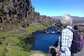 unconcern in front of us we tried to take
photos. It was a sickening illustration of why we travel, to escape from the
horrors of modern uncouth humanity. Yet here we were in the midst of the very
worst of it: they had no interest in or curiosity about these unbelievable
natural surroundings. Why do they come? we yet again asked.
unconcern in front of us we tried to take
photos. It was a sickening illustration of why we travel, to escape from the
horrors of modern uncouth humanity. Yet here we were in the midst of the very
worst of it: they had no interest in or curiosity about these unbelievable
natural surroundings. Why do they come? we yet again asked.
The pathway led along the bed of Almannagjá to Öxarárfoss
waterfalls (see left) (Photo
31- Öxarárfoss falls), where the Öxará River spills over the 30m high
basalt brink from the Kerlingarhraun
lava field above, dropping into Almannagjá to flow south along the length of the
gorge (Photo
32 - Öxará River). Saga legend has it that the river's course was diverted to provide fresh
drinking water for those who gathered in their buðs for the summer
meeting of the Alþing. Today the sun shone giving the falling water a
sparkle, unlike our last visit on a dull day in 1972. The other difference was
that 45 years ago, we had the privilege of enjoying this wonderful natural
setting alone; today the board-walk at foot of the falls was crowded
with tourists who indifferently clambered over the rocks simply to
take their selfies. looking up towards upper basalt wall of Almannagjá")
 With the onward chasm now filled with the Öxará
River, the on-going pathway dropped down below Almannagjá's lower wall, and led along to
where the river emerged from the canyon to flow across the plain below towards
its outflow into Þingvallavatn (Photo
33 - Öxará emerging from gorge) (see above right). This was the view which in 1972 we had been able
to photograph from high above on the upper brink of Almannagjá at the edge of
the Kerlingarhraun lava field. Looking along the gorge now was the nearest 2017
equivalent photo, with access today being understandably restricted from walking the
upper brink of the ravine. As we descended to the lower path, we found a couple
of Field Gentians to be photographed, as tourists swarmed past evidently puzzled
at why we were photographing flowers! With the onward chasm now filled with the Öxará
River, the on-going pathway dropped down below Almannagjá's lower wall, and led along to
where the river emerged from the canyon to flow across the plain below towards
its outflow into Þingvallavatn (Photo
33 - Öxará emerging from gorge) (see above right). This was the view which in 1972 we had been able
to photograph from high above on the upper brink of Almannagjá at the edge of
the Kerlingarhraun lava field. Looking along the gorge now was the nearest 2017
equivalent photo, with access today being understandably restricted from walking the
upper brink of the ravine. As we descended to the lower path, we found a couple
of Field Gentians to be photographed, as tourists swarmed past evidently puzzled
at why we were photographing flowers!
From here we continued along the now dry ravine to
the notional position of the Lög Berg (Law Rock), the rocky outcrop from
where speakers had addressed the Alþing, today marked by Iceland's
national flag blowing in the increasing wind (see above left) (Photo
34 - Lög Berg - Law Rock). Looking eastwards from the Law
Rock, one could imagine those attending the
 Alþing
assembled on the plain below (see below right); to the south, the Öxará River meandered towards
its outflow into Þingvallavatn (see above right). But the Law Rock was again swarming
with tourists, many simply taking selfies or behaving with childish antics, not
one of them however showing any interest or Alþing
assembled on the plain below (see below right); to the south, the Öxará River meandered towards
its outflow into Þingvallavatn (see above right). But the Law Rock was again swarming
with tourists, many simply taking selfies or behaving with childish antics, not
one of them however showing any interest or understanding of the landmark so
symbolically significant for Icelanders. We continued along the upper part of
the Almannagjá cleft line under the shadow of the western tectonic plate
boundary cliff, where the ravine was now fragmented into a subsidiary fissure
fracturing (see left). The path sloped up through the gap to the top of the cleft leading
to the look-out point at Hakið for further photos looking eastwards across
the plain and Þingvallahraun lava field (see right), and southwards towards Lake Þingvallavatn
(Photo
35 - Öxará outflow into Þingvallavatn). Back down through the cleft gap, we crossed the lava
ridge of Sluttistigur, again marvelling at the magnificent slab of Pahoe-hoe
lava flow, tilted upwards by the tectonic forces that had created the fissure (Photo
36 - Pahoe-hoe lava flow) (see below left). Again
the tourists surged past with supreme indifference, to gather at the viewpoint
for more selfies and silly behaviour. Today we found an exit path sloping down
on the far side to the lower Öxará River. The Hotel Valhöll once stood here,
close to where quite amazingly we had wild-camped in 1972. Along the far bank of
the river, we reached Þingvellir church, built in the 19th century on the same
spot as the first church built at the adoption of Christianity in 1000 AD (Photo
37 - Þingvellir Church). understanding of the landmark so
symbolically significant for Icelanders. We continued along the upper part of
the Almannagjá cleft line under the shadow of the western tectonic plate
boundary cliff, where the ravine was now fragmented into a subsidiary fissure
fracturing (see left). The path sloped up through the gap to the top of the cleft leading
to the look-out point at Hakið for further photos looking eastwards across
the plain and Þingvallahraun lava field (see right), and southwards towards Lake Þingvallavatn
(Photo
35 - Öxará outflow into Þingvallavatn). Back down through the cleft gap, we crossed the lava
ridge of Sluttistigur, again marvelling at the magnificent slab of Pahoe-hoe
lava flow, tilted upwards by the tectonic forces that had created the fissure (Photo
36 - Pahoe-hoe lava flow) (see below left). Again
the tourists surged past with supreme indifference, to gather at the viewpoint
for more selfies and silly behaviour. Today we found an exit path sloping down
on the far side to the lower Öxará River. The Hotel Valhöll once stood here,
close to where quite amazingly we had wild-camped in 1972. Along the far bank of
the river, we reached Þingvellir church, built in the 19th century on the same
spot as the first church built at the adoption of Christianity in 1000 AD (Photo
37 - Þingvellir Church).
 Exploring the Þingvallahraun lava field fissures:
but time was moving on if we were to explore other major fissures
in the Þingvallahraun lava field. With the increasing wind now blowing in our
faces, we walked back northwards across the lava field to the Exploring the Þingvallahraun lava field fissures:
but time was moving on if we were to explore other major fissures
in the Þingvallahraun lava field. With the increasing wind now blowing in our
faces, we walked back northwards across the lava field to the car parks, passing
the Flossagjá fissure flooded by spring water (see right) (Photo
38 - Flossagjá flooded fissure). We drove back to the campsite,
and turned eastwards on Route 36, finding road-side parking at the start of the Leirastigur path, recommended at the Information Centre. From here we followed
way-marks along the brink of the Sleðaásgjá fissure (see below left) (Photo
39 - Sleðaásgjá fissure-fault), another of the
'stretch-mark' faults ripped across the line of the rift-valley by the
separating tectonic plate movement and by earthquakes. The entire lava field
north of Route 36 was rent apart by a swarm of such dramatically deep faults and
fissures, and was covered with birch scrub, Tea-leaved Willow (Salix
phylicifolia) and delicate moss (see below right). It was rough terrain along the brink of the
deep fissures, and with the wind now gusting furiously, we contented ourselves
with taking a series of photos and returned to the road. car parks, passing
the Flossagjá fissure flooded by spring water (see right) (Photo
38 - Flossagjá flooded fissure). We drove back to the campsite,
and turned eastwards on Route 36, finding road-side parking at the start of the Leirastigur path, recommended at the Information Centre. From here we followed
way-marks along the brink of the Sleðaásgjá fissure (see below left) (Photo
39 - Sleðaásgjá fissure-fault), another of the
'stretch-mark' faults ripped across the line of the rift-valley by the
separating tectonic plate movement and by earthquakes. The entire lava field
north of Route 36 was rent apart by a swarm of such dramatically deep faults and
fissures, and was covered with birch scrub, Tea-leaved Willow (Salix
phylicifolia) and delicate moss (see below right). It was rough terrain along the brink of the
deep fissures, and with the wind now gusting furiously, we contented ourselves
with taking a series of photos and returned to the road.
We drove further northwards on the minor Route 550
across the Sleðaáshraun lava field, alongside Leiragjá fissure and the
northernmost section of
 Almannagjá, around under the foot of the over-towering Ármannsfell
volcanic peak. This southern end of Route 550 in fact continued for some 40kms across the remote volcanic highlands of Bláskógaheiðí past the foot of the Skaldbreiður
shield volcano, to emerge
at its northern end in Upper Borgarfjörður where we had wild-camped 2 weeks ago
(see our log).
The mountain road passed through an area of Almannagjá, around under the foot of the over-towering Ármannsfell
volcanic peak. This southern end of Route 550 in fact continued for some 40kms across the remote volcanic highlands of Bláskógaheiðí past the foot of the Skaldbreiður
shield volcano, to emerge
at its northern end in Upper Borgarfjörður where we had wild-camped 2 weeks ago
(see our log).
The mountain road passed through an area of sandur (sand and gravel deposits)
and crossed the heads of fissures to rise over the crest of the northern end of Sleðaásgjá fissure. We parked and walked back above the head of the 20m deep
fissure opening (see below left) (Photo
40 - Sleðaásgjá fissure), to look out across the broad Þingvallahraun lava field stretching away into the
distance across the Þingvellir rift-valley. This was indeed formidably wild
country, showing the scale of this dramatic volcanic terrain ripped apart over
aeons by tectonic movement (see right). sandur (sand and gravel deposits)
and crossed the heads of fissures to rise over the crest of the northern end of Sleðaásgjá fissure. We parked and walked back above the head of the 20m deep
fissure opening (see below left) (Photo
40 - Sleðaásgjá fissure), to look out across the broad Þingvallahraun lava field stretching away into the
distance across the Þingvellir rift-valley. This was indeed formidably wild
country, showing the scale of this dramatic volcanic terrain ripped apart over
aeons by tectonic movement (see right).
A wild day in camp at Þingvellir National Park Nyrðri-Leirar campsite:
with the wind now becoming more forceful, we
returned to Þingvellir National Park Nyrðri-Leirar campsite. Today had been
another that could rank among the most exciting of a unique trip. It had been
like standing in the midst of a living geology text book: there was simply so
much to get your head around, and the questions just kept on coming. Later as we
looked at our photos, we were still trying to puzzle out some answers. And the comically
tragic fact was that the majority of the 1000s of tourists who visit Þingvellir simply milled around with
utterly
 indifferent oblivion to what the titanic forces of nature had created
around them, as well as to the historic and cultural significance of Þingvellir
for Icelanders. indifferent oblivion to what the titanic forces of nature had created
around them, as well as to the historic and cultural significance of Þingvellir
for Icelanders.
 We settled back in snugly against the shelter of
the birch-scrub vegetation for shelter from the wind (see right), and hunkered down for a
rough night. With George buffeted overnight by gale-force winds, there was
no need for an earthquake simulator in this weather! With the wind forecast to
be even stronger today, it was an easy decision to take a day in camp here and
sit out the gales. The wind eased a little during the afternoon, but was still
gusting strongly by the time tent campers began arriving early evening. We had
seen many examples of ill-preparedness for Icelandic weather conditions and
inexperience in erecting tents during the 4 months of this trip so far, but
tonight's display capped it all: a group of 4 spent over 1½ hours struggling to
erect their marquee-sized tent in the gusting wind, declining offers of help!
The wind was still blowing when we turned in, but the forecast was for a full
day of sun tomorrow.
We settled back in snugly against the shelter of
the birch-scrub vegetation for shelter from the wind (see right), and hunkered down for a
rough night. With George buffeted overnight by gale-force winds, there was
no need for an earthquake simulator in this weather! With the wind forecast to
be even stronger today, it was an easy decision to take a day in camp here and
sit out the gales. The wind eased a little during the afternoon, but was still
gusting strongly by the time tent campers began arriving early evening. We had
seen many examples of ill-preparedness for Icelandic weather conditions and
inexperience in erecting tents during the 4 months of this trip so far, but
tonight's display capped it all: a group of 4 spent over 1½ hours struggling to
erect their marquee-sized tent in the gusting wind, declining offers of help!
The wind was still blowing when we turned in, but the forecast was for a full
day of sun tomorrow.
Laugarvatn and Haukadalur:
the following morning dawned sunny but still the wind was fresh. Finally
leaving Þingvellir, we headed east on Route 36 across the full 5kms width of the
scrub-covered Þingvallahraun lava field, criss-crossed by its lines of
stretch-mark fissures (click
here for detailed map of route). On the far side, the road rose up
through the Hrafnagjá line of fissures which mark the
European plate boundary on the eastern side of the rift-valley depression. Here
we pulled into a lay-by to look out across the magnificent spectacle of the
rift-valley's full width, bounded at the northern end by the bulky massif of Ármannsfell,
at the southern end by the shimmering waters of Þingvallavatn, and behind us to
the east by the craggy heights of Hrafnabörg. Somewhere, lost in the centre of
the scrub-covered valley depression, was the abandoned farm of Skógarkot. The
line of the Almannagjá gorge, marking the American plate boundary was just
visible on the western side of the scrub-covered valley. The road finally rose
up through the line of Gildruholtsgjá and Bæjargjá fissure cliffs which mark the
boundary of the rift-depression on its eastern side. Beyond the abandoned farm
of Gjábakki, with the southward view towards Þingvallavatn now blocked by the
lakeside crater of Arnarfell, we reached the junction with the Selfoss road, and
turned eastwards on Route 365 across the open moorland of Lyngdalsheiði. To the
south, the flat, conical shield volcano of Þrasaborgir rose as a low bulge, and
a line of craggy volcanic peaks marked the northern skyline. The road continued eastwards across the moorland,
finally dropping down to Laugarvatn by its volcanically warm lake which gives
the town its name. Further to the SE, the larger
lake of Apavatn was visible. We turned into the little town and inspected its
municipal campsite which seemed straightforwardly acceptable as an option for
tonight. Having topped up our provisions at the well-stocked Samkaut mini-market
by the filling station, we continued eastwards around Laugardalur towards Geysir.
This clearly was green, fertile farming country with many horses, and contrasted
sharply with the volcanic wild-lands we had recently travelled through. Ahead
rose the prominent peak of Bjarnarfell (which we had climbed in 1972) on the
approach to Geysir.
 Haukadalur and the spouting hot springs at Geysir:
despite the numbers of tourist hire-cars and tour-buses at Geysir parking area,
we just about managed to find a space to sit and eat our lunch sandwiches,
putting off facing the inevitable hordes which we feared would sully our
memories of camping here at Geysir in the happy tourist-free days of 1972. The
Great Geysir, named from the Old Norse/Icelandic verb geysa meaning to
gush, and set in the small geothermal area of Haukadalur, has given its name
to hot spouting springs (geysers) the world over. Geysir had been one of the
first volcanic phenomena, ejecting a column of boiling water and steam at
regular intervals to a height of 70m, that attracted visitors during the
19th Haukadalur and the spouting hot springs at Geysir:
despite the numbers of tourist hire-cars and tour-buses at Geysir parking area,
we just about managed to find a space to sit and eat our lunch sandwiches,
putting off facing the inevitable hordes which we feared would sully our
memories of camping here at Geysir in the happy tourist-free days of 1972. The
Great Geysir, named from the Old Norse/Icelandic verb geysa meaning to
gush, and set in the small geothermal area of Haukadalur, has given its name
to hot spouting springs (geysers) the world over. Geysir had been one of the
first volcanic phenomena, ejecting a column of boiling water and steam at
regular intervals to a height of 70m, that attracted visitors during the
19th century. But in 1916, Geysir became dormant, unless provoked into spouting
activity by throwing soap into the vent. Seismic activity in the area has
occasionally re-awakened Geysir's spouting. There are a number of other boiling
pools nearby, but the only one currently erupting on a regular basis is Strokkur
(meaning Churn). century. But in 1916, Geysir became dormant, unless provoked into spouting
activity by throwing soap into the vent. Seismic activity in the area has
occasionally re-awakened Geysir's spouting. There are a number of other boiling
pools nearby, but the only one currently erupting on a regular basis is Strokkur
(meaning Churn).
Geysers erupt because the particular layout of
underground channels, chambers and pipes allows thermal water ascending through
the channels to boil at some depth below the surface. At around 23m depth in the
geyser vent-pipe, the water is superheated to 120ºC by underlying magma
intrusions, in equilibrium with the pressure of water above; the weight of water
above sustains the super-boiling rate like the lid of a kettle. The turbulence
of the increasingly boiling water can be seen on the surface of the vent pool.
As the boiling turbulence increases, a chain reaction begins: a huge convex
bubble or blister forms on the surface water at the vent, causing increasing
amounts of boiling water lower down to flash into high pressure steam; this
occupies a much greater volume of space in the narrow channel than water,
forcing the water above upwards in the vent-pipe to be erupted high into the air
as a column of boiling water followed by high pressure steam. After all the
water/steam volume in the pipe has been ejected into the air, the water falls
refilling the vent-pipe, and draining back down into channels deep in the earth's
crust, for the eruptive cycle to begin anew. For regular, vertically erupting
geysers to occur, the depth and temperature of the magma heat source, the size of the
water chamber, and the diameters of the entry and exit vents, all need to be
precisely synchronised, which makes geysers a rare phenomenon. Seismic and
volcanic activity may
 create new geysers or cause existing ones to become
dormant, as happened with Great Geysir. Robert Bunsen, the German chemist, who
visited Geysir in 1846, was one of the first to point to an accurate explanation
of the hydrothermal-mechanics of geyser eruptions caused by the pressure of
superheated steam in the depths of the vent pipe. create new geysers or cause existing ones to become
dormant, as happened with Great Geysir. Robert Bunsen, the German chemist, who
visited Geysir in 1846, was one of the first to point to an accurate explanation
of the hydrothermal-mechanics of geyser eruptions caused by the pressure of
superheated steam in the depths of the vent pipe.
Our 2017 visit to Geysir:
with misgivings about the swarms of tourists and the inevitable restrictions on access compared with the privileged peace and freedom we had enjoyed on our 1972
visit, we walked over to the geothermal area. Posters proudly boasted of the
further changes to be made to convert this natural space into even more of an
horrendous 'tourist attraction'! We walked up past other now dormant hot springs
and boiling pools which simmered away quietly (see above left); one of these we recognised as the
boiling pool where Paul had boiled breakfast eggs suspended on strings in the
naturally boiling water (see above right)
(Photo
41 - Boiling pool at Geysir); our 1972~2017 time-lapse comparison photos show the
contrast in freedom of access at Geysir. These days, access to the pools was inevitably
constrained by rope barriers, and the tourist industry had assigned each of the
springs twee names; in the glory days of 1972, this whole area was almost
entirely free of tourists, with unrestricted access to the natural pools and
their steaming drainage channels and sinter-lined basins. It was then our
responsibility to take ultra care on the crusty, sulphur-stained ground to avoid
damaging the fragile surface.
access compared with the privileged peace and freedom we had enjoyed on our 1972
visit, we walked over to the geothermal area. Posters proudly boasted of the
further changes to be made to convert this natural space into even more of an
horrendous 'tourist attraction'! We walked up past other now dormant hot springs
and boiling pools which simmered away quietly (see above left); one of these we recognised as the
boiling pool where Paul had boiled breakfast eggs suspended on strings in the
naturally boiling water (see above right)
(Photo
41 - Boiling pool at Geysir); our 1972~2017 time-lapse comparison photos show the
contrast in freedom of access at Geysir. These days, access to the pools was inevitably
constrained by rope barriers, and the tourist industry had assigned each of the
springs twee names; in the glory days of 1972, this whole area was almost
entirely free of tourists, with unrestricted access to the natural pools and
their steaming drainage channels and sinter-lined basins. It was then our
responsibility to take ultra care on the crusty, sulphur-stained ground to avoid
damaging the fragile surface.
") Ahead up the slope, tourists in droves gathered around the rope barriers now
restricting close access to the sinter-lined vent of Strokkur, the one remaining
spouting geyser. In contrast in 1972, with not a tourist in sight, we were able
to stand close by while waiting for the tell-tale huge aquamarine convex bubble to
form at the vent's surface, prefacing the start of another eruption as the column
of boiling water and steam burst high into the air with Ahead up the slope, tourists in droves gathered around the rope barriers now
restricting close access to the sinter-lined vent of Strokkur, the one remaining
spouting geyser. In contrast in 1972, with not a tourist in sight, we were able
to stand close by while waiting for the tell-tale huge aquamarine convex bubble to
form at the vent's surface, prefacing the start of another eruption as the column
of boiling water and steam burst high into the air with a whoosh. Again it was
our responsibility to avoid the scalding shower of falling water following the
eruption. Imagine the untold erosion damage to the fragile sinter surround to
the basin, and the number of screaming, scalded tourists if that freedom of access
were allowed now! We managed to secure spaces by the outer-side rope barrier,
at a high point from where we could see the vent-pool to get some fore-warning
of an impending eruption. On this side, the tourists crowds were not as bad as
feared, and in fact, such was the tourists' brief span of attention or the tight schedule of
their tour-buses, that immediately following an eruption of the geyser, they all
disappeared to be replaced by the next arriving crowd! Between eruptions, the sense of excited anticipation caused general
quietness, and the next whooshing eruption was greeted with oohs and cheers.
Eruptions
happened with fairly predictable regularity every 8~10 minutes, and between
times with the geyser quiescent there was some minor
gurgling around the sinter-lined vent
(Photo
42 - Strokkur basin between eruptions); again we have paired all our 2017 photos with their
now rather grainy1972 equivalents. We
set our cameras for continuous shoot and poised ready, pending the warning signs of impending activity: the
formation of an initial 2m wide swelling surface-bubble (see above left)
(Photo
43 - Bubble pre-empting eruption), followed by the bubble's bursting as the next
eruption whooshed into the air (see above right)
(Photo
44 - Eruption bubble bursting). In a matter of seconds, the bubble burst upwards
with the column of scalding water being ejected between 30 to 40m into the air
(see left)
(Photo
45 - Strokkur erupting),
then collapsing in a shower of boiling spray
(see right)
(Photo
46 - Collapsing shower of boiling spray), and the residual steam hovering and
drifting for several further seconds in the air
before
dissipating
(Photo
47 - Dissipating steam); and finally, the fallen water drained back re-filling the vent channel
(Photo
48 - Post-eruption drainage). We were able to take both continuous shoot
sequences and videos, showing the whole sequence of eruption from initial
swelling and bursting of the bubble, ejection of boiling water and steam, and the
post-eruption re-filling of the basin: a whoosh. Again it was
our responsibility to avoid the scalding shower of falling water following the
eruption. Imagine the untold erosion damage to the fragile sinter surround to
the basin, and the number of screaming, scalded tourists if that freedom of access
were allowed now! We managed to secure spaces by the outer-side rope barrier,
at a high point from where we could see the vent-pool to get some fore-warning
of an impending eruption. On this side, the tourists crowds were not as bad as
feared, and in fact, such was the tourists' brief span of attention or the tight schedule of
their tour-buses, that immediately following an eruption of the geyser, they all
disappeared to be replaced by the next arriving crowd! Between eruptions, the sense of excited anticipation caused general
quietness, and the next whooshing eruption was greeted with oohs and cheers.
Eruptions
happened with fairly predictable regularity every 8~10 minutes, and between
times with the geyser quiescent there was some minor
gurgling around the sinter-lined vent
(Photo
42 - Strokkur basin between eruptions); again we have paired all our 2017 photos with their
now rather grainy1972 equivalents. We
set our cameras for continuous shoot and poised ready, pending the warning signs of impending activity: the
formation of an initial 2m wide swelling surface-bubble (see above left)
(Photo
43 - Bubble pre-empting eruption), followed by the bubble's bursting as the next
eruption whooshed into the air (see above right)
(Photo
44 - Eruption bubble bursting). In a matter of seconds, the bubble burst upwards
with the column of scalding water being ejected between 30 to 40m into the air
(see left)
(Photo
45 - Strokkur erupting),
then collapsing in a shower of boiling spray
(see right)
(Photo
46 - Collapsing shower of boiling spray), and the residual steam hovering and
drifting for several further seconds in the air
before
dissipating
(Photo
47 - Dissipating steam); and finally, the fallen water drained back re-filling the vent channel
(Photo
48 - Post-eruption drainage). We were able to take both continuous shoot
sequences and videos, showing the whole sequence of eruption from initial
swelling and bursting of the bubble, ejection of boiling water and steam, and the
post-eruption re-filling of the basin:
We spent an hour taking and both photos and videos of successive eruptions, then moved around to the far side for
closer shots. Boiling water streamed down the hill-side, over-spilling from Strokkur's basin. Access restrictions now kept the crowds back from the danger
zone around the sinter-lined basin, which in 1972 we had been able to approach
for close-up shots as the initial bubble welled up, and as post-eruption falling
waters drained back into the vent.
We spent a further half hour photographing further eruptions, then followed the
roped-off walk-ways uphill to the now dormant twin boiling pools of Blesi (Blazer):
one was at boiling point and totally clear, the other was just below boiling
temperature and murky with dissolved silica. Both pools were lined with a
delicate rim of beautiful sinter, and made a tranquil foreground for distant
photos of erupting Strokkur
(Photo
49 - Blesi's twin boiling pools) (see left). At the brow of the hill,
the boiling pool of Konungshver stood with its clear aquamarine water, and further over on its own
high, sinter-formed brow, we reached the now dormant original Great Geysir (see
right)
(Photo
50 - Great Geysir). We
returned down hill, across
 the streams of boiling water over-spilling from Strokkur's
basin, recalling our 5 days of peaceful wild-camping here at Geysir in 1972 when we had
grown accustomed to the point of almost indifference to Strokkur's regular eruptions;
we savoured the memories of such privileged freedom (see left) (Photo
51 - 1972 camp at Geysir). the streams of boiling water over-spilling from Strokkur's
basin, recalling our 5 days of peaceful wild-camping here at Geysir in 1972 when we had
grown accustomed to the point of almost indifference to Strokkur's regular eruptions;
we savoured the memories of such privileged freedom (see left) (Photo
51 - 1972 camp at Geysir).
Gullfoss waterfalls and the Hvíta river gorge: we continued up-valley, crossing the Tungufljót
river which drains down from Sandvatn and Langjökull in the highlands beyond Haukadalur. The terrain became wilder as we approached Gullfoss. If we had
thought Geysir had been tourist-ridden, here at Gullfoss the hordes were simply
horrendous, with the huge car parks overflowing. In contrast in 1972, there had
been just a few tourists, but 45 years later these natural surroundings in the
wild lands of the upper Hvíta gorges were totally overwhelmed by the crowds. The Hvíta
(meaning White River) glacial river, draining southwards from Langjökull
in the remote highland interior, thunders into a wide, curved 3-step staircase
at Gullfoss (meaning Golden Falls), plunging abruptly over 2 sets of
falls, the first 11m deep then the second set of falls 21m high twisting right angles into a crevice 32m deep and 20m wide, followed by a basalt-lined
canyon 2.5kms in length. On a sunny day rainbows form in the spray hovering
above the falls, and looking up-river into the highlands interior, the ice-cap
of Langjökull glacier is clearly visible on the sky-line. in the highlands beyond Haukadalur. The terrain became wilder as we approached Gullfoss. If we had
thought Geysir had been tourist-ridden, here at Gullfoss the hordes were simply
horrendous, with the huge car parks overflowing. In contrast in 1972, there had
been just a few tourists, but 45 years later these natural surroundings in the
wild lands of the upper Hvíta gorges were totally overwhelmed by the crowds. The Hvíta
(meaning White River) glacial river, draining southwards from Langjökull
in the remote highland interior, thunders into a wide, curved 3-step staircase
at Gullfoss (meaning Golden Falls), plunging abruptly over 2 sets of
falls, the first 11m deep then the second set of falls 21m high twisting right angles into a crevice 32m deep and 20m wide, followed by a basalt-lined
canyon 2.5kms in length. On a sunny day rainbows form in the spray hovering
above the falls, and looking up-river into the highlands interior, the ice-cap
of Langjökull glacier is clearly visible on the sky-line.
 We followed the walk-way along to the higher view-point which gave an overview
of Gullfoss' upper double falls with rainbow created by the spray (see right)
(Photo
52 - Gullfoss upper falls). To take photos meant having to jostle in the crowds for a position, and
risk being poked in the face by
tourists' selfie-sticks. As the Hvíta dropped from its upper course over the
falls, the river water was an opaque grey from all the sediment washed down from
its glacial source (see below right) (Photo
53 - Glacial River Hvíta). We followed the walk-way along to the higher view-point which gave an overview
of Gullfoss' upper double falls with rainbow created by the spray (see right)
(Photo
52 - Gullfoss upper falls). To take photos meant having to jostle in the crowds for a position, and
risk being poked in the face by
tourists' selfie-sticks. As the Hvíta dropped from its upper course over the
falls, the river water was an opaque grey from all the sediment washed down from
its glacial source (see below right) (Photo
53 - Glacial River Hvíta).
 Having taken photos looking across the foaming breadth of the
upper falls, we descended to the lower walk-way. Spray ballooned upwards from
where the lower falls turned at right angles to plunge into the narrow chasm
(see left)
(Photo
54 - Gullfoss basalt gorge), forming rainbows above the gorge. In 1972,
the rocky platform projecting outwards immediately above the upper falls was
entirely unprotected, needing ultra-care; today rope-barriers kept the swarming
tourists from falling headlong into the torrent. We clambered up onto the rocky outcrop which gave
a view over the spray billowing up above where the lower falls plunged into the
tightly confined, dark chasm, to continue flowing on down the length of the
lower canyon with its walls of columnar basalt. Back along to a grassy knoll
gave the classic view looking up-river to the full sweep of the double set of
falls with its rainbow arching above
(see below left) (Photo
55 - Rainbow over Gullfoss). Spray billowing up from the gorge covered our camera lens as we stood
to take photos (see below left and right) to match those taken from this same spot in 1972. Having taken photos looking across the foaming breadth of the
upper falls, we descended to the lower walk-way. Spray ballooned upwards from
where the lower falls turned at right angles to plunge into the narrow chasm
(see left)
(Photo
54 - Gullfoss basalt gorge), forming rainbows above the gorge. In 1972,
the rocky platform projecting outwards immediately above the upper falls was
entirely unprotected, needing ultra-care; today rope-barriers kept the swarming
tourists from falling headlong into the torrent. We clambered up onto the rocky outcrop which gave
a view over the spray billowing up above where the lower falls plunged into the
tightly confined, dark chasm, to continue flowing on down the length of the
lower canyon with its walls of columnar basalt. Back along to a grassy knoll
gave the classic view looking up-river to the full sweep of the double set of
falls with its rainbow arching above
(see below left) (Photo
55 - Rainbow over Gullfoss). Spray billowing up from the gorge covered our camera lens as we stood
to take photos (see below left and right) to match those taken from this same spot in 1972.
 Skjól Camping in Upper Haukadalur, and our first sighting of the Aurora Borealis:
we drove sadly away from Gullfoss; of all the natural sites visited in Iceland,
this had without doubt been the most sullied by overwhelming volume of tourist
hordes, even more so than Goðafoss in the north. Returning down-valley from the
wild moorland around the upper Hvíta to the gentler farmland of the lower valley, we reached Skjól Camping at the Kjóastaðir horse rearing farmstead. This
was an expensive site at Skjól Camping in Upper Haukadalur, and our first sighting of the Aurora Borealis:
we drove sadly away from Gullfoss; of all the natural sites visited in Iceland,
this had without doubt been the most sullied by overwhelming volume of tourist
hordes, even more so than Goðafoss in the north. Returning down-valley from the
wild moorland around the upper Hvíta to the gentler farmland of the lower valley, we reached Skjól Camping at the Kjóastaðir horse rearing farmstead. This
was an expensive site at 1,200kr/person (800kr seniors' reduction), plus 900kr for
power, and showers charged extra at 400kr each; but it accepted the camping-card,
and we used the 24th slot on our card. Facilities were modern but limited in the
extreme with just one set of unisex WCs, tiny hand basins unusable for washing, and
cold water outside wash-up sinks. Its good position partway between Gullfoss and
Geysir had suited our route well, but with its high price and limited
facilities, we rated it at +2. The camping area was a large, open grassy field
sloping uphill, and we pitched towards the top. From the camper's doorway, we
could look northwards with clear views of the Langjökull glacier, and 3kms
down-valley we could just see the column of steam rising from Strokkur's regular
eruptions every 10 minutes. So both in 1972 and in 2017, we had camped within
sight of the erupting Strokkur at Geysir (see below right). 1,200kr/person (800kr seniors' reduction), plus 900kr for
power, and showers charged extra at 400kr each; but it accepted the camping-card,
and we used the 24th slot on our card. Facilities were modern but limited in the
extreme with just one set of unisex WCs, tiny hand basins unusable for washing, and
cold water outside wash-up sinks. Its good position partway between Gullfoss and
Geysir had suited our route well, but with its high price and limited
facilities, we rated it at +2. The camping area was a large, open grassy field
sloping uphill, and we pitched towards the top. From the camper's doorway, we
could look northwards with clear views of the Langjökull glacier, and 3kms
down-valley we could just see the column of steam rising from Strokkur's regular
eruptions every 10 minutes. So both in 1972 and in 2017, we had camped within
sight of the erupting Strokkur at Geysir (see below right).
 Weary after a long day, we settled in early on a dark, chill evening, but waking
at 3-00am Paul noticed that what he initially thought were lines of cloud in
the otherwise clear sky, were in fact wavering, misty grey-green streaks of pale light shimmering across the sky; we were witnessing for the very first time the Aurora
Borealis. We were both too befuddled with sleep to focus cameras, so no Aurora
photos tonight despite unimpeded views on this open farmland. Weary after a long day, we settled in early on a dark, chill evening, but waking
at 3-00am Paul noticed that what he initially thought were lines of cloud in
the otherwise clear sky, were in fact wavering, misty grey-green streaks of pale light shimmering across the sky; we were witnessing for the very first time the Aurora
Borealis. We were both too befuddled with sleep to focus cameras, so no Aurora
photos tonight despite unimpeded views on this open farmland. But with this run
of fine weather forecast to continue, we hoped for a repeat performance to
secure photos of the Aurora. But with this run
of fine weather forecast to continue, we hoped for a repeat performance to
secure photos of the Aurora.
Skálholt ecclesiastical centre: it was time now finally to leave Haukadalur and to
head for more peaceful areas away from the tourist throngs. Back along this
green and fertile farming valley where horses grazed the lush fields, we turned
off onto the quiet Route 35 following the middle course of the Tungufljót river
to reach the rural town of Reykholt, a small horticultural and farming
settlement with geothermally heated greenhouses growing fruit and vegetables (click
here for detailed map of route). None of these were open on a Sunday for
us to buy fresh vegetables, and we continued down the valley, turning off onto
Route 31 to Skálholt.
Skálholt developed as the most important ecclesiastical and cultural centre in
Iceland after Christianity became the country's official religion by decree of
 the Alþing in 1000 AD. The clan chieftain Gissur the White had introduced
Christianity at the behest of the fiery evangelising Norwegian King Ólafur Tryggvason. Gissur's son, Ísleifur Gissurarson, ordained in 1056 AD as Iceland's
first bishop, made his farmstead at
Skálholt his episcopal seat and established a school there, with a second
episcopal centre established at Hólar in the north in 1106 AD. The new religion
increased its power, wealth and landholdings with the introduction of tithes
(property taxes); as its wealth grew, the Church founded monasteries and
schools, bringing education and the beginning of literature to Iceland. This
resulted in the compilation of the Íslendingabók recording the lineage of the
founding settlers, the first book written not in Latin the language of the Church but in
native Icelandic. During
the time of Þorlákur the Alþing in 1000 AD. The clan chieftain Gissur the White had introduced
Christianity at the behest of the fiery evangelising Norwegian King Ólafur Tryggvason. Gissur's son, Ísleifur Gissurarson, ordained in 1056 AD as Iceland's
first bishop, made his farmstead at
Skálholt his episcopal seat and established a school there, with a second
episcopal centre established at Hólar in the north in 1106 AD. The new religion
increased its power, wealth and landholdings with the introduction of tithes
(property taxes); as its wealth grew, the Church founded monasteries and
schools, bringing education and the beginning of literature to Iceland. This
resulted in the compilation of the Íslendingabók recording the lineage of the
founding settlers, the first book written not in Latin the language of the Church but in
native Icelandic. During
the time of Þorlákur Þórhallsson, Bishop of Skálholt 1178~11198, who was later canonised as Iceland's patron saint, a huge
wooden cathedral was built at Skálholt which developed as an ecclesiastical school and powerful centre of
learning. The Catholic bishopric at Skálholt lasted until the Reformation in 1550, which resulted in the execution
at Skálholt of Jón Arason the last Catholic Bishop of Hólar for his resistance to
the Danish monarchy's enforced conversion to Lutheranism.
Skálholt continued as a Lutheran centre of religion and education until the
wooden cathedral was destroyed by an earthquake in 1797 and the bishopric was
moved to Reykjavík. Skálholt was largely abandoned until the modern cathedral and theological centre
was restored in 1963. Þórhallsson, Bishop of Skálholt 1178~11198, who was later canonised as Iceland's patron saint, a huge
wooden cathedral was built at Skálholt which developed as an ecclesiastical school and powerful centre of
learning. The Catholic bishopric at Skálholt lasted until the Reformation in 1550, which resulted in the execution
at Skálholt of Jón Arason the last Catholic Bishop of Hólar for his resistance to
the Danish monarchy's enforced conversion to Lutheranism.
Skálholt continued as a Lutheran centre of religion and education until the
wooden cathedral was destroyed by an earthquake in 1797 and the bishopric was
moved to Reykjavík. Skálholt was largely abandoned until the modern cathedral and theological centre
was restored in 1963.
Today as you approach Skálholt, the modern cathedral is visible from a distance
standing in isolation on a green hillock. We parked and walked over to the
elegantly plain church (see above left), and inside, sunlight streaming in through the abstract
design stained glass windows cast a beautiful coloured
 light
across the vertical lines of the nave, and the tapestry-like mosaic of Christ
filling the east-end wall (see right) (Photo
56 - Skalholt Cathedral)
(see right). Reconstruction work and subsequent archaeological excavations revealed the
foundations of the medieval ecclesiastical settlement which had developed around Skálholt,
and uncovered a 13th century stone sarcophagus containing the remains of the 7th
Bishop of Skálholt, Páll Jónsson, now displayed in the cathedral crypt (see
left). A
reconstruction of an early turf-built church stands alongside the modern
cathedral. light
across the vertical lines of the nave, and the tapestry-like mosaic of Christ
filling the east-end wall (see right) (Photo
56 - Skalholt Cathedral)
(see right). Reconstruction work and subsequent archaeological excavations revealed the
foundations of the medieval ecclesiastical settlement which had developed around Skálholt,
and uncovered a 13th century stone sarcophagus containing the remains of the 7th
Bishop of Skálholt, Páll Jónsson, now displayed in the cathedral crypt (see
left). A
reconstruction of an early turf-built church stands alongside the modern
cathedral.
Kerið Crater: from Skálholt, we drove on to Laugarás, another
horticultural and farming community, where we managed to buy locally grown
tomatoes from the geothermally heated greenhouses. Route 35 brought us
SW-wards, initially through farming countryside then across the Grímnes lava
field, now dotted with estates of summer houses. From a distance the distinctive
outline of the scoria crater row of Seyðishólar and Kerhólar stood out on the
sky-line. Passing these, we reached the lower crater of Kerið, but so also had
hordes of hire-car tourists! We had so far enjoyed a wonderfully peaceful tourist-free afternoon, but suddenly, as we approached the Ring Road, we
had caught up with them again. The car park was full and overflowing, and
tourists swarmed like ants all around the crater brim. Kerið was on private
land, and the owners were charging 400kr admission. With essential provisions
shopping still to do in Selfoss and a distance to drive to reach tonight's
campsite in Þjórsárdalur, we were in two minds about whether to stop. But we gave
it half an hour, paid our admission, and set off to walk the crater rim.
tourist-free afternoon, but suddenly, as we approached the Ring Road, we
had caught up with them again. The car park was full and overflowing, and
tourists swarmed like ants all around the crater brim. Kerið was on private
land, and the owners were charging 400kr admission. With essential provisions
shopping still to do in Selfoss and a distance to drive to reach tonight's
campsite in Þjórsárdalur, we were in two minds about whether to stop. But we gave
it half an hour, paid our admission, and set off to walk the crater rim.
 Kerið is one of several calderas in the Grímnes lava field; 55m deep, 170m wide
and 270m in length, it is around 3,000 years old and half the age of the other
neighbouring volcanic features. Most of the inside of the crater is steep-sided
bare volcanic rock, but one wall slopes gently inwards with a pathway down to
the water-filled crater bottom. The lake depth varies between 7 and 14m
depending on the water table, and is a vivid opaque aquamarine in colour. The
deep red, frothy light pumice lava forming the scoria cone gave every appearance
of the crater having been caused by a classic explosion eruption. But further
studies in the Grímnes region failed to establish any evidence of ash deposits
that could be traced to an explosion eruption forming the Kerið Crater. It is
now believed that as much as half the Tjanarhólarhraun lava flowed from the Kerið
cone volcano, and that its present form originates from an eruption which
emptied the magma chamber beneath the scoria crater. Once the magma reserve was
depleted towards the end of the eruption, the weight of the cone resulted in the
crater collapsing into the empty magma chamber. The site owners had certainly
constructed a worthwhile infrastructure, with a clear pathway around the crater
rim, and stepped walkway down into the water-filled basin of the crater.
Although we had no time to descend into the inner crater, we completed the walk
around the brim, taking our photos (see above left and right). Kerið is one of several calderas in the Grímnes lava field; 55m deep, 170m wide
and 270m in length, it is around 3,000 years old and half the age of the other
neighbouring volcanic features. Most of the inside of the crater is steep-sided
bare volcanic rock, but one wall slopes gently inwards with a pathway down to
the water-filled crater bottom. The lake depth varies between 7 and 14m
depending on the water table, and is a vivid opaque aquamarine in colour. The
deep red, frothy light pumice lava forming the scoria cone gave every appearance
of the crater having been caused by a classic explosion eruption. But further
studies in the Grímnes region failed to establish any evidence of ash deposits
that could be traced to an explosion eruption forming the Kerið Crater. It is
now believed that as much as half the Tjanarhólarhraun lava flowed from the Kerið
cone volcano, and that its present form originates from an eruption which
emptied the magma chamber beneath the scoria crater. Once the magma reserve was
depleted towards the end of the eruption, the weight of the cone resulted in the
crater collapsing into the empty magma chamber. The site owners had certainly
constructed a worthwhile infrastructure, with a clear pathway around the crater
rim, and stepped walkway down into the water-filled basin of the crater.
Although we had no time to descend into the inner crater, we completed the walk
around the brim, taking our photos (see above left and right).
Final call at Selfoss: it was by now
5-15pm, and time to head back to Selfoss. As we approached the junction with
Route 36, ahead loomed the now familiar bulky outline of Ingólfsfjall table
mountain silhouetted against the late afternoon western sun. We had passed this
way a number of times in the last week, to return to Route 1 Ring Road
which was now very busy with weekenders hastening back to Reykjavík. We turned
eastwards into Selfoss, rushing along to the supermarkets before they closed for
the day. This service centre town had served us well over the last week and had
become a familiar place. Having completed our shopping, we now had a 30kms drive
to reach tonight's campsite in Þjórsárdalur.
Coming next: we shall now continue our
journey along Iceland's southern coast, firstly with a circuit of the volcanic
valley of Þjórsárdalur, and is still a fertile farming valley. But
brooding over Þjórsárdalur is the evil presence of Hekla, one of the country's
most destructive volcanoes. The higher reaches of the Þórsá River are also
exploited by a sequence of hydro-electric schemes, controversial because of
their environmental impact. We shall then pass through the region around Hella,
historically significant as the area associated with Njál's Saga, before
crossing to Heimaey to camp on the Westman Islands off the south coast, site of
the destructive 1973 eruption of Eldfell which necessitated evacuation of the
town's citizens. The Westman Islands archipelago are also famous as home to one
of Iceland's largest colonies of Puffins, and the 1963 undersea eruption which
created the new island of Surtsey. On returning to the mainland, we shall camp
under the Eyjafjallajökull volcano whose sub-glacial eruption in 2010 brought a
week-long disruption to air traffic across Europe caused by the plume of
volcanic ash. We shall continue our travel along the southern coast to Vík,
which nestles under the deadly Katla volcano and Mýrdalsjökull glacier. But all of that is for our next
Icelandic edition, to be
published in the autumn.
Next Icelandic edition to be published in the autumn
|
Sheila and Paul |
Published: 5 July 2019 |
|

